
GL175
Australian Soil Classification: Bleached-Mottled, Eutrophic, Brown CHROMOSOL (Confidence level 1)
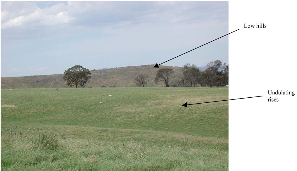
General Landscape Description: Undulating rises
Site Description: Lower slope with 6% slope
Land Unit: Ararat Schists
Geology: Cambrian schists
General Land Unit Description: This land unit forms the hills of metamorphic schists. The soils tend to be quite shallow, often around 60 cm in depth. There can be a bleached A2 horizon. In some cases, particularly on the steeper slopes and crests, there can be many quartz coarse fragments, usually above the clay subsoil. The most common landform is undulating rises, which this soil type represents. The soil becomes shallower and banded rock outcrops become more apparent the steeper the land. The capability of the low hills and hills land units are limited due to the slope, rock outcrops and shallow soils, as well as the susceptibility to water erosion. The gently undulating plains generally form the lower slopes of the rises and have a better capability for land use options due to a more favourable landscape and generally deeper soils.
Soil Profile Morphology:
Horizon | Depth (cm) | |||
A1 | 0–30 | Dark brown (10YR3/3); sandy loam; weak coarse angular blocky structure; very firm consistence, dry; pH 5.9; abrupt change to: | 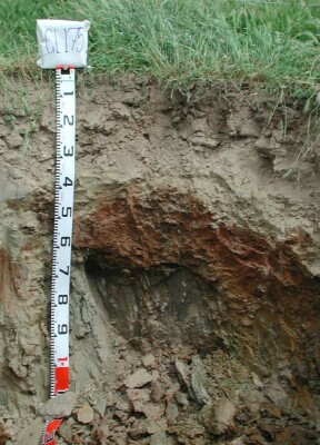 | |
A2 | 30–45 | Yellowish brown (10YR5/6), conspicuously bleached (10YR8/2d); sandy loam; massive structure; firm to very firm consistence, dry; contains many large angular quartz coarse fragments; pH 6.5; clear but wavy change to: | ||
B2 | 45–60 | Yellowish brown (10YR5/6), with many distinct red (2.5YR4/8) mottles; medium heavy clay; strong very coarse prismatic parting to strong coarse angular blocky structure; very firm consistence, dry; pH 7.0; changes to: | ||
C | 60–120 | Weathered rock. | ||
Soil Profile Characteristics:
- | pH | Salinity | ||
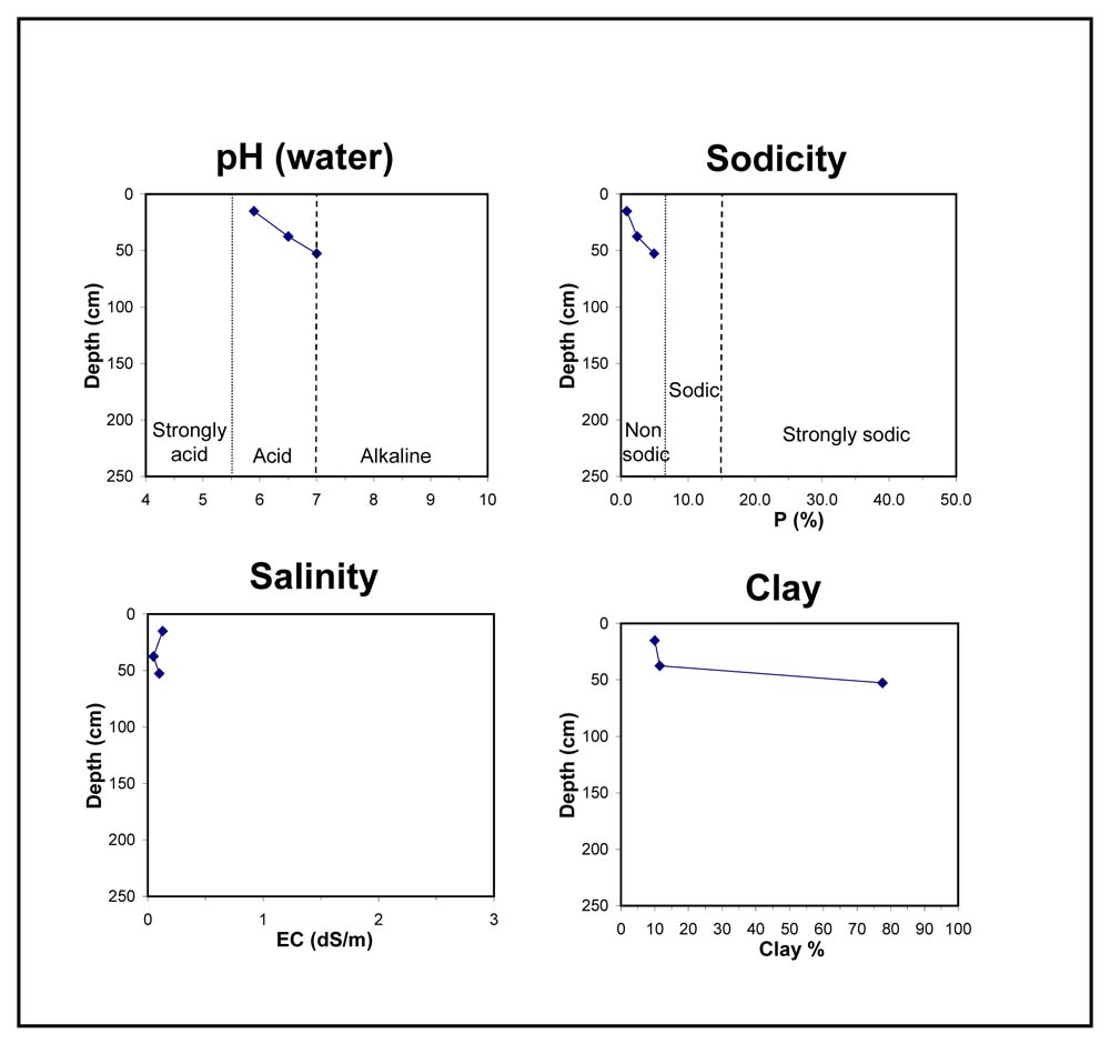
Surface Soil (A1 horizon) | Moderately Acid | Very Low | Non Sodic | None |
Subsoil (45-60 cm) | Neutral | Very Low | Non Sodic | None |
Chemical and Physical Analysis:
Horizon | Horizon Depth (cm) | pH (water) | pH (CaCl2) | EC dS/m | Organic Carbon % | Total Nitrogen % | Exchangeable Aluminium ppm | Exchangeable Acididty meq/100g | Exchangeable Cations | Coarse Sand (0.2-2.0 mm) % | Fine Sand (0.02-0.2 mm) % | Silt (0.002-0.02 mm) % | Clay (<0.002 mm) % | Field Capacity % w/w | Wilting Point % w/w | |||
Ca | Mg | K | Na | |||||||||||||||
meq/100g | ||||||||||||||||||
A1 | 0–30 | 5.9 | 5.2 | <0.05 | 1.7 | 0.12 | <10 | 7.1 | 3.3 | 1.1 | 0.91 | 0.11 | 16 | 52 | 16 | 10 | 22.9 | 7.3 |
A2 | 30–45 | 6.7 | 5.8 | <0.05 | 2.9 | 1.2 | 0.92 | 0.26 | 0.13 | 18 | 51 | 19 | 12 | 19.5 | 4.5 | |||
B2 | 45–60 | 7.0 | 6.2 | 0.1 | 0 | 5.5 | 10 | 0.94 | 0.84 | 3 | 11 | 9 | 78 | 46.3 | 27.9 | |||
Key Profile Features:
- Strong texture contrast between topsoil and subsoil
- Shallow soil
- Many coarse fragments in A2 horizon
- Bleached A2 horizon
- Mottled subsoil
- A2 horizon dispersive when dry
Profile Described By: David Rees, December 2002.
© State of Victoria (Agriculture Victoria) 1996 - .

This work, Victorian Resources Online, is licensed under a Creative Commons Attribution 4.0 licence. You are free to re-use the work under that licence, on the condition that you credit the State of Victoria (Agriculture Victoria) as author, indicate if changes were made and comply with the other licence terms.
The licence does not apply to ‘branding’ or some ‘images or photographs’ that may be owned by third parties. We ask you to seek prior approval to use images using the VRO feedback form. Access to higher quality images can also be provided on request.
This page was last updated on .