
GL166
Location: Ballyrogan
Australian Soil Classification: Sodic, Mesotrophic, Red CHROMOSOL (confidence level 1)
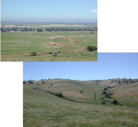
General Landscape Description: Low Hills
Site Description: Mid-slope (13%)
Land Unit: Ararat Marine Siltstone
Geology: Cambrian marine sediments
General Land Unit Description: The dominant landform of this land unit is dissected undulating rises (GL171), although there are some rolling low hills (represented by this site) and some undulating plains that are mainly at the footslopes of the rises. The major land element is the gentler footslopes of the undulating rises and plains. The major soil type found on these slopes tend to be reddish and well structured strong texture contrast soils (Chromosols) (GL171). The subsoil can be quite acidic and there may be high aluminium levels in some soils. There is evidence of an occasional bleach horizon. The soils are often quite shallow. The topsoil and subsoils tend to be acidic. The soils on the dissected rolling low hills are generally shallow, although they can be quite well structured. They are commonly sodic Red Chromosols. Banded sedimentary rock outcrop is common on these soil types, especially on the exposed westerly aspects. Gully erosion on the plains below these hills and on the drainage depression is quite severe.
Soil Profile Morphology:
| Surface Soil | 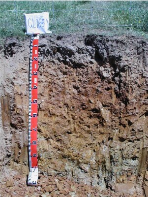 | ||
| A1 | 0-20 cm | Brown (10YR4/3); clay loam; weak medium subangular blocky parting to moderate very fine subangular blocky structure; weak consistence, dry; contains many medium angular coarse quartz pebbles; pH 5.7; clear change to: | |
Subsoil | |||
| B2 | 20-50 cm | Yellowish red (7.5YR4/6); medium clay; strong medium prismatic parting to strong medium polyhedralstructure; common medium angular quartz pebbles are present; pH 6.5; gradual change to: | |
| B3/C | 50-80 cm | Strong brown (7.5YR5/6), with common distinct medium yellowish red (5YR4/6) mottles; light clay; weak medium polyhedral structure; pH 7.0. clear and wavy change to: | |
| C | 80-100 cm |
Key Profile Features:
- Many coarse fragments above the B2 horizon
- Sodic at depth
- Strong texture contrast between topsoil and subsoil
- Subsoil dispersive when worked when wet
Soil Profile Characteristics:
- | pH | Salinity | ||
Surface Soil (A1 horizon) | Moderately Acid | Low to Medium | Non-Sodic | None |
Subsoil (20-50 cm) | Slightly Acid | Very Low | Non-Sodic | None1 |
Deeper Subsoil (50 -80 cm) | Neutral | Very Low | Sodic | None2 |
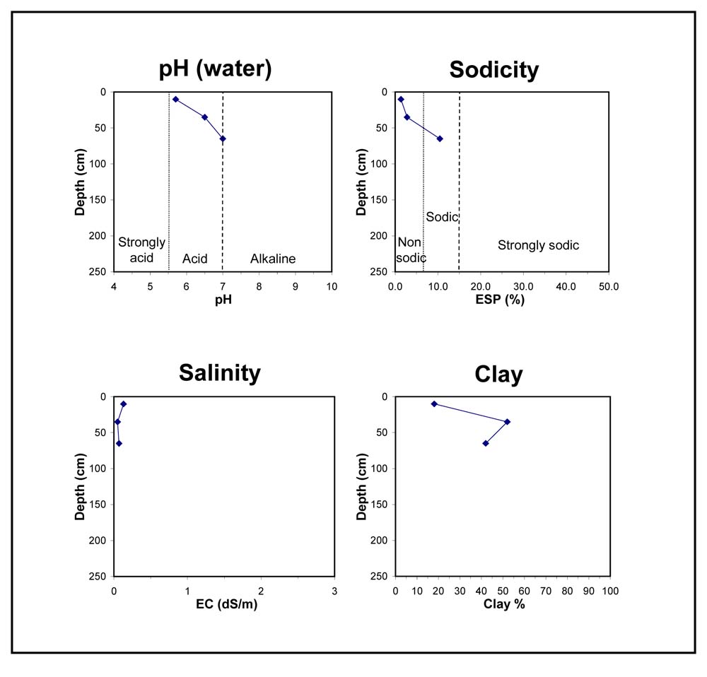
Chemical and Physical Analysis:
Horizon | Horizon Depth (cm) | pH (water) | pH (CaCl2) | EC dS/m | Organic Carbon % | Total Nitrogen % | Exchangeable Aluminium ppm | Exchangeable Acididty meq/100g | Exchangeable Cations | Coarse Sand (0.2-2.0 mm) % | Fine Sand (0.02-0.2 mm) % | Silt (0.002-0.02 mm) % | Clay (<0.002 mm) % | Field Capacity % w/w | Wilting Point % w/w | |||
Ca | Mg | K | Na | |||||||||||||||
meq/100g | ||||||||||||||||||
A1 | 0-20 | 5.7 | 5.0 | 0.13 | 2.4 | 0.21 | <10 | 8.9 | 4.1 | 1.7 | 0.76 | 0.21 | 8 | 41 | 29 | 18 | 33.2 | 9.3 |
B2 | 20-50 | 6.5 | 5.5 | 0.05 | 7.1 | 1.8 | 5 | 0.57 | 0.41 | 8 | 18 | 24 | 52 | 30.7 | 18.6 | |||
B3 | 50-80 | 7.0 | 6.0 | 0.07 | 0.98 | 4.6 | 0.35 | 0.7 | 11 | 26 | 22 | 42 | 34.6 | 17.4 | ||||
Profile Described By: Natalie Baxter and Keith Raynard, 27th November 2000.
© State of Victoria (Agriculture Victoria) 1996 - .

This work, Victorian Resources Online, is licensed under a Creative Commons Attribution 4.0 licence. You are free to re-use the work under that licence, on the condition that you credit the State of Victoria (Agriculture Victoria) as author, indicate if changes were made and comply with the other licence terms.
The licence does not apply to ‘branding’ or some ‘images or photographs’ that may be owned by third parties. We ask you to seek prior approval to use images using the VRO feedback form. Access to higher quality images can also be provided on request.
This page was last updated on .