
GL163
Australian Soil Classification: Haplic, Petroferric, Brown CHROMOSOL (confidence level 1)
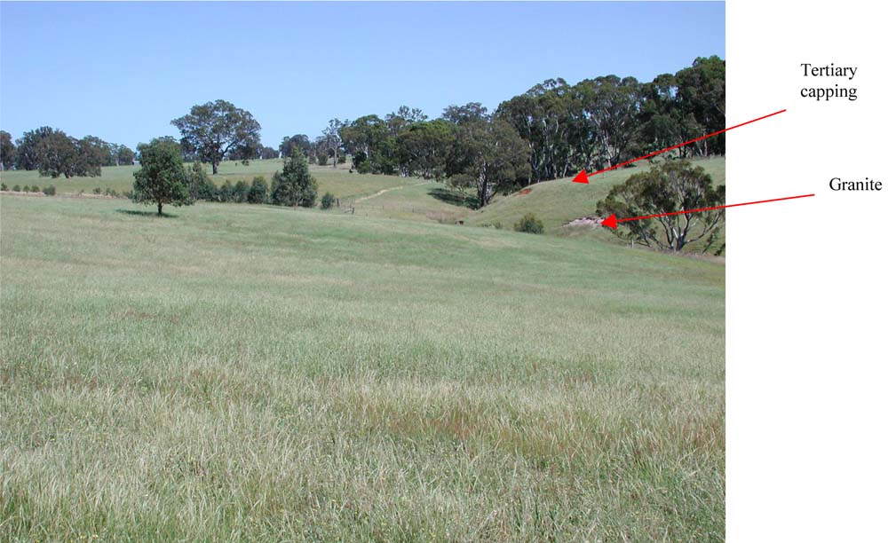
General Landscape Description: Low Hills / Rises
Site Description: Upper slope
Land Unit: Dundas Sedimentary
Geology: Tertiary marine sandstone
General Land Unit Description: This site is situated on low hills with a Tertiary capping. Due to restrictions of scale, this site is not mapped as the Dundas land unit. It has been used to illustrate the variability in the parent material in the dissected landforms in the north-west of the study area. The most distinguishing feature of this soil is a thin petroferric pan. The pan occurs at 60 cm, which is slightly deeper than is common. Underneath the pan there is a band of heavy clay that overlies Tertiary quartz river gravels, which have proven to be gold bearing. The river gravels are not necessarily common. The petroferric pan may be the result of a fluctuating watertable.
Soil Profile Morphology:
| Surface Soil | 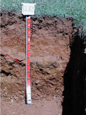 | ||
| A11 | 0-15 cm | Reddish brown (10YR5/4); fine sandy loam, moderate medium to fine subangular blocky structure; weak consistence, dry; pH 5.1; gradual change to: | |
| A12 | 15-30 cm | Yellowish red (5YR4/6); fine sandy loam; weak fine subangular blocky structure; weak consistence, dry; contains many medium subangular ferruginous nodules; pH 5.4; abrupt and wavy change to: | |
| Subsoil | |||
| B21 | 30-60 cm | Yellowish red (50YR4/6) with very few fine faint yellow mottles; medium clay; weak subangular blocky structure; firm consistence, dry; contains a few small subangular ferruginous nodules; pH 5.9; sharp and wavy change to: | |
| Pan | 60-75 cm | Very strongly cemented continuous ferruginous pan; sharp and wavy change to: | |
| B22 | 75-90 cm | Red (2.5YR4/6) , with many coarse prominent yellowish brown (10YR5/6) mottles; heavy clay, moderate polyhedral structure; strong consistence, dry; contains very few fine ferruginous nodules; pH 6.0; clear to gradual change to: | |
| B23 | 90-130 cm | Quartz river gravels |
Soil Profile Characteristics:
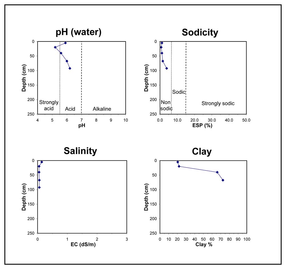
- | pH | Salinity | ||
Surface Soil (A11 horizon) | Strongly Acid | Very Low | Non-Sodic | None1 |
Subsoil (30-60 cm) | Moderately Acid | Very Low | Non-Sodic | None |
Deeper Subsoil (75 -90 cm) | Moderately Acid | Very Low | Non-Sodic | None |
Chemical and Physical Analysis:
Horizon | Horizon Depth (cm) | pH (water) | pH (CaCl2) | EC dS/m | Organic Carbon % | Total Nitrogen % | Exchangeable Aluminium ppm | Exchangeable Acididty meq/100g | Exchangeable Cations | Coarse Sand (0.2-2.0 mm) % | Fine Sand (0.02-0.2 mm) % | Silt (0.002-0.02 mm) % | Clay (<0.002 mm) % | Field Capacity % w/w | Wilting Point % w/w | |||
Ca | Mg | K | Na | |||||||||||||||
meq/100g | ||||||||||||||||||
| A11 | 0-15 cm | 5.1 | 4.3 | <0.05 | 2.7 | 0.17 | 46 | 9.4 | 1.2 | 0.43 | 0.41 | 0.08 | 27 | 47 | 10 | 13 | 17.7 | 7.2 |
| A12 | 15-30 cm | 5.4 | 4.7 | <0.05 | 12 | 6.3 | 1.8 | 0.71 | 0.2 | 0.07 | 26 | 45 | 11 | 20 | 17.7 | 7.8 | ||
| B21 | 30-60 cm | 5.9 | 5.3 | <0.05 | <10 | 6.7 | 3.0 | 2.1 | 0.24 | 0.1 | 22 | 30 | 7 | 43 | 25.2 | 14.3 | ||
| B22 | 75-90 cm | 6.0 | 5.8 | 0.05 | <10 | 6.1 | 2.9 | 4.2 | 0.15 | 0.15 | 7 | 27 | 9 | 59 | 35.4 | 21.3 | ||
Key Profile Features:
- Acidic topsoil
- Strong texture contrast between topsoil and subsoil
- Mottled subsoil
- Cemented petroferric pan
- Topsoil dispersive when worked when wet
Profile Described By:
© State of Victoria (Agriculture Victoria) 1996 - .

This work, Victorian Resources Online, is licensed under a Creative Commons Attribution 4.0 licence. You are free to re-use the work under that licence, on the condition that you credit the State of Victoria (Agriculture Victoria) as author, indicate if changes were made and comply with the other licence terms.
The licence does not apply to ‘branding’ or some ‘images or photographs’ that may be owned by third parties. We ask you to seek prior approval to use images using the VRO feedback form. Access to higher quality images can also be provided on request.
This page was last updated on .