
GL100
Location: Casterton
Australian Soil Classification: Melanic, Subnatric, Brown SODOSOL (confidence level 1)
General Landscape Description: Rises, low hills
Site Description: Upper slope, 10%.
Land Unit: Merino Tablelands
Geology: Cretaceous non-marine sandstone
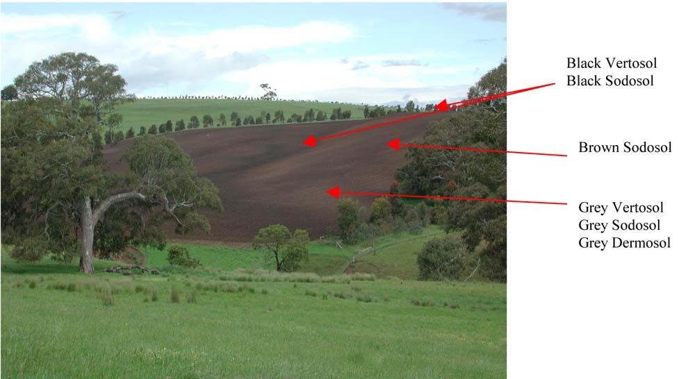
General Land Unit Description: This unit consists of the Cretaceous non-marine sandstone of the dissected Merino Tablelands. The tablelands were thought to have formed under swamp conditions and a warm climate. As a result, the soils tend to be high in clay and there tends to be carbon rich seams of charcoal deposits at depth in some of the profiles. The main soil type used to represent this land unit is black cracking clays (Vertosols) that can be sodic at depth. This soil type, along with Black Sodosols, Chromosols and Dermosols, are commonly found on the broad crests or drainage lines. The slopes often consist of Brown Chromosols, Sodosols or Dermosols, although black soils can also occur on the slopes. The lower slopes commonly have Grey Vertosols or Sodosols as the major soil type. The reasonably deep sodic soils on short steep slopes tend to be prone to landslips. The grey soils, in particular are prone to water erosion.
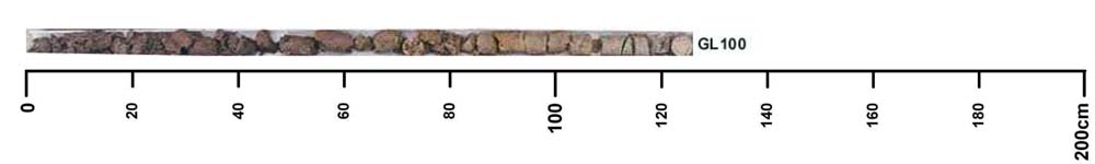
Soil Profile Morphology
| A1 | 0-20 cm | Very dark brown (10YR2/2); clay loam; strong very fine subangular blocky structure; very firm consistence, dry; contains very few sedimentary fragments; pH 5.8; changes to: |
| Subsoil | ||
| B21 | 20-40 cm | Dark brown (10YR3/3); light medium clay; medium to strong medium columnar to subangular blocky structure; very firm consistence, dry; pH 6.2; changes to: |
| B22 | 40-60 cm | Dark brown (10YR3/3), with common orange mottles; medium clay; weak to medium subangular blocky structure; very firm consistence, moderately moist; pH 7.3; changes to: |
| B23 | 60-80 cm | Brown (10YR4/3), with many light brown mottles; medium heavy clay; weak to medium subangular blocky structure; very firm consistence, moderately moist; pH 8.3; changes to: |
| B3 | 80-95 cm | Light olive brown (10YR5/4); fine sandy light clay; very firm consistence, moderately moist; pH 9.1; changes to: |
| BC | 95-105 cm | |
| C | 105+ cm |
Key profile features:
- Alkaline subsoil
- Sodic subsoil
- Mottled subsoil
- Topsoil dispersive when worked when wet
- Top of subsoil dispersive when worked when wet
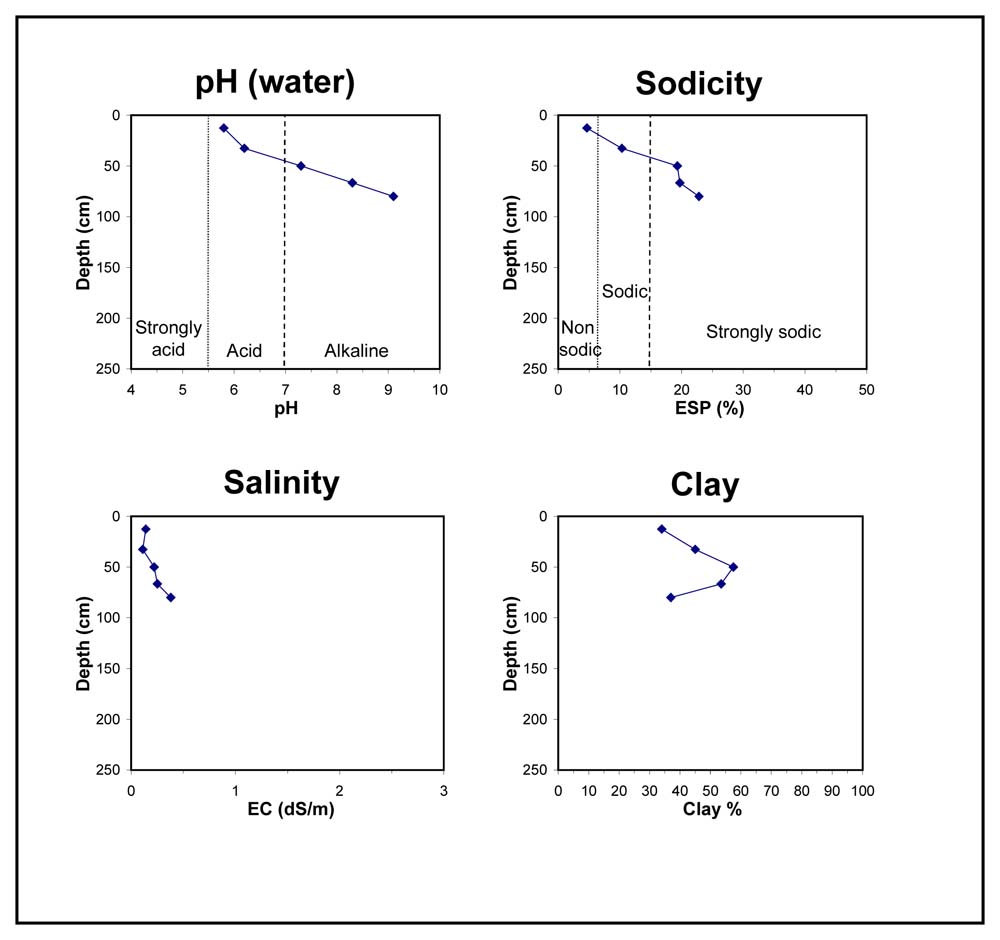
Soil Profile Characteristics:
- | pH | Salinity | ||
Surface Soil (A1 horizon) | Moderately Acid | Low | Non-Sodic | None1 |
Subsoil (20-40cm) | Slightly Acid | Very Low | Sodic | None2 |
Deeper Subsoil (80 -95 cm) | Very Strongly Alkaline | Medium | - | Strong2 |
Chemical and Physical Analysis:
Horizon | Horizon Depth (cm) | pH (water) | pH (CaCl2) | EC dS/m | Organic Carbon % | Total Nitrogen % | Exchangeable Aluminium ppm | Exchangeable Acididty meq/100g | Exchangeable Cations | Coarse Sand (0.2-2.0 mm) % | Fine Sand (0.02-0.2 mm) % | Silt (0.002-0.02 mm) % | Clay (<0.002 mm) % | Field Capacity % w/w | Wilting Point % w/w | |||
Ca | Mg | K | Na | |||||||||||||||
meq/100g | ||||||||||||||||||
A1 | 0-20 | 5.8 | 4.8 | 0.14 | 2.5 | 0.25 | 27 | 16 | 4.9 | 5.3 | 0.84 | 1.3 | 2 | 32 | 27 | 34 | 36.5 | 18.4 |
B21 | 20-40 | 6.2 | 4.7 | 0.11 | 63 | 15 | 3.7 | 8.2 | 0.98 | 3.2 | 1 | 25 | 26 | 45 | 39.0 | 20.6 | ||
B22 | 40-60 | 7.3 | 6.1 | 0.22 | 6.1 | 16 | 1.3 | 5.6 | 1 | 19 | 21 | 58 | 48.2 | 25.7 | ||||
B23 | 60-80 | 8.3 | 7.3 | 0.25 | 6.9 | 18 | 1.2 | 6.5 | 1 | 22 | 23 | 54 | 49.1 | 28.6 | ||||
B3 | 80-95 | 9.1 | 8.2 | 0.39 | 5 | 28 | 29 | 37 | 47.4 | 28.8 | ||||||||
Profile Described By: Natalie Baxter and Grant Boyle, 9th October 2000.
© State of Victoria (Agriculture Victoria) 1996 - .

This work, Victorian Resources Online, is licensed under a Creative Commons Attribution 4.0 licence. You are free to re-use the work under that licence, on the condition that you credit the State of Victoria (Agriculture Victoria) as author, indicate if changes were made and comply with the other licence terms.
The licence does not apply to ‘branding’ or some ‘images or photographs’ that may be owned by third parties. We ask you to seek prior approval to use images using the VRO feedback form. Access to higher quality images can also be provided on request.
This page was last updated on .