
GHF13c
Location: Heywood
Australian Soil Classification: Melacic, Eutrophic, Brown FERROSOL
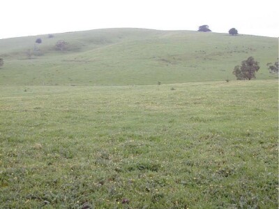
General Landscape Description: Undulating rises to low hills
Site Description: Lower slope
Land Unit: Drumborg Basalt Hills
Geology: Quaternary basalt
General Land Unit Description:
This land unit consists of the undulating rises of Sugarloaf Hill and Sheaok Rise, north of Heywood. The soils consist of Red Dermosols and occasionally Kurosols on the crests and slopes of the rises. On the lower slopes and plains in between the rises, Ferric Brown Chromosols or Dermosols predominate. There are minor occurrences of Black Vertosols in local depressions. Here a two year old Eucalyptus globulus plantation exists on ex-agricultural land
Soil Profile Morphology
Surface
| A1 | 0-20 cm | Dark brown (10YR3/3) clay loam, moderate granular structure (10-20 mm) parting to moderate granular structure (2-5 mm), very weak consistence when moderately moist, few medium ferruginous nodules, common medium roots. Abrupt and smooth transition to: | 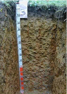 |
| Subsoil | |||
| B21 | 20-60 cm | Yellowish brown (10YR5/6) with common coarse distinct red (2.5YR4/6) mottles, light clay, moderate polyhedral structure (20-50 mm) parting to moderate polyhedral structure (5-10 mm), weak consistence when moderately moist, few medium ferruginous nodules, few fine macropores, areal porosity 0.3%, common very fine roots. Diffuse and smooth transition to: | |
| B22 | 60-100 cm | Yellowish brown (10YR5/6) with many coarse distinct red (2.5YR4/6) mottles, light clay, moderate polyhedral structure (20-50 mm) parting to moderate polyhedral structure (5-10 mm), weak consistence when moderately moist, few medium ferruginous nodules, few fine macropores, areal porosity 0.3%, few very fine roots. Gradual and smooth transition to: | |
| B23 | 100-150 cm | Red (2.5YR4/6) with many coarse prominent light yellowish brown (10YR6/4) mottles, light clay, strong polyhedral structure (20-50 mm) parting to strong polyhedral structure (5-10 mm), firm consistence when moderately moist, few medium ferruginous nodules, few fine macropores, areal porosity 0.3%, few very fine roots. | |
| 150-400 cm | Medium clays, a little harder with depth but no impeding layer to roots, decomposing rock between 350-400 cm, and may become impeding to roots, live roots found at 350-400 cm. |
Soil Profile Characteristics:
- | pH | Salinity | |
Surface Soil (A1 horizon) | Strongly Acid | Very Low | Non-Sodic |
Subsoil (B21 Horizon) | Slightly Acid | Very Low | Non-Sodic |
Deeper Subsoil (150-180 cm) | Slightly Acid | Very Low | Non-Sodic |
Chemical and Physical Analysis:
Horizon | Horizon Depth (cm) | pH (water) | pH (CaCl2) | EC dS/m | Exchangeable Aluminium ppm | Exchangeable Acididty meq/100g | Exchangeable Cations | Coarse Sand (0.2-2.0 mm) % | Fine Sand (0.02-0.2 mm) % | Silt (0.002-0.02 mm) % | Clay (<0.002 mm) % | |||
Ca | Mg | K | Na | |||||||||||
meq/100g | ||||||||||||||
A1 | 0-20 | 5.3 | 4.8 | 0.08 | 35 | 14 | 3.6 | 2.5 | 0.29 | 0.12 | 21 | 28 | 14 | 30 |
B21 | 20-60 | 6.2 | 6.0 | 0.10 | <10 | 12 | 2.8 | 5.6 | 0.13 | 0.64 | 9 | 15 | 10 | 61 |
B22 | 60-100 | 6.1 | 6.0 | 0.12 | <10 | 11 | 2.7 | 5.8 | 0.13 | 0.87 | 9 | 12 | 11 | 65 |
Profile Described By: Ian Sargeant and Paul Feikema, 25th July 2000.
© State of Victoria (Agriculture Victoria) 1996 - .

This work, Victorian Resources Online, is licensed under a Creative Commons Attribution 4.0 licence. You are free to re-use the work under that licence, on the condition that you credit the State of Victoria (Agriculture Victoria) as author, indicate if changes were made and comply with the other licence terms.
The licence does not apply to ‘branding’ or some ‘images or photographs’ that may be owned by third parties. We ask you to seek prior approval to use images using the VRO feedback form. Access to higher quality images can also be provided on request.
This page was last updated on .