
GHF02b
Location: Cavendish
Australian Soil Classification: Fragic, Humic, Aquic, PODOSOL
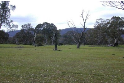
General Landscape Description: Sand plain
Site Description: Flat
Land Unit: Grampians Plains
Geology: Quaternary alluvial
General Land Unit Description: This land unit consists of the alluvial plains around the Grampians. The soils are commonly poorly drained Grey Sodosols in association with Podosols. Some areas experience months of inundation. These soils are commonly Hydrosols. The vegetation is mainly thick scrubby tea tree on the wetter soils.
This site is near the base of the Grampians, and it appears that water drains onto the alluvial plains from the Grampians. Apparently groundwater closer to the Grampians (about 1 km to the east) is at a depth of 3 m. Currently there exists a 1.5 year old E. globulus plantation on ex-agricultural land.
Soil Profile Morphology
| A1 | 0-35 cm | Black (10YR2/1); loamy sand;single grain structure; loose consistence,moist; clear and smooth change to: | 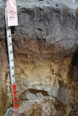 |
| Subsoil | |||
| Bh | 35-65 cm | Dark brown (7.5YR3/4); loamy sand; single grain structure; loose consistence, moist; gradual and smooth change to: | |
| B2 | 65-90 cm | Yellow (10YR7/6); sand; single grain structure; loose consistence, moist; gradual and smooth change to: | |
| C | 90-140 cm | Pinkish white (7.5YR8/2); sand; single grain structure; loose consistence, wet; changes to: | |
| 140-300 cm | Clay layer (not hard) observed at 250-300 cm, sands below this layer, anaerobic conditions (smell of hydrogen sulphide). | ||
Notes: The PSP takes in an area of poor tree growth and survival. An additional pit in an area of better growth and survival revealed no apparent difference in soil profiles that would lead to the observed differences in tree growth.
Profile Described By: Ian sargeant, Paul Feikema, Martin Clark and Kiet Quach, 26th October 2000.
© State of Victoria (Agriculture Victoria) 1996 - .

This work, Victorian Resources Online, is licensed under a Creative Commons Attribution 4.0 licence. You are free to re-use the work under that licence, on the condition that you credit the State of Victoria (Agriculture Victoria) as author, indicate if changes were made and comply with the other licence terms.
The licence does not apply to ‘branding’ or some ‘images or photographs’ that may be owned by third parties. We ask you to seek prior approval to use images using the VRO feedback form. Access to higher quality images can also be provided on request.
This page was last updated on .