
CRC14
Australian Soil Classification: Bleached-Mottled, Magnesic, Red KUROSOL
General Landscape Description: Upper slope of hill.
Site Description: Grazing paddock - CRC plant evaluation site.
Geology: Metamorphic aureole.
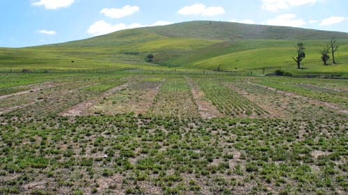 CRC14 Landscape |
Soil Profile Morphology
Surface Soil
A1 | 0-12 cm | Brown (7.5YR5/4); fine sandy clay loam; weak-moderate blocky structure; firm consistence (dry); pH 5.3; clear change to: | 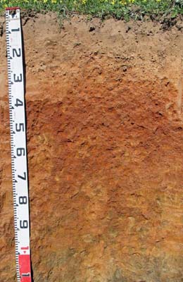 CRC14 Profile |
| A2 | 12-30 cm | Reddish yellow (7.5YR6/6) conspicuously bleached (7.5YR7/4 dry); fine sandy loam+; weak to moderate medium-fine blocky; weak consistence (moderately moist); few (5-10%) quartz fragments (2-5 mm); pH 4.9; clear abrupt change to: | |
| Subsoil | |||
| B21 | 30-45 cm | Dark red (2.5YR4/8); medium clay; strong medium to fine to very fine blocky structure; firm consistence (moderately moist); shiny-faced peds; pH 5.4: | |
| B22 | 45-70 cm | Dark red (2.5YR4/8) with red (7.5YR6/8) mottles; medium clay; strong medium fine-very fine blocky structure; firm consistence (moderately moist); shiny-faced peds; pH 5.6: | |
| B23 | 70-90 cm | Reddish yellow (7.5YR6/8) with dark red (2.5YR4/8) mottles; medium clay; strong very fine prismatic, parting to moderate to strong coarse-medium blocky structure; firm to very firm consistence (moderately moist); shiny-faced peds; pH 6.1: | |
| B24 | 90-110 cm | Reddish yellow (7.5YR6/8) with yellowish red (5YR5/8) mottles; silty clay loam; moderate very coarse prismatic, parting to strong coarse blocky structure; very firm consistence (moderately moist); some weathered micaceous rock (very soft); pH 6.3: | |
| B/C | 110-130 cm | Yellowish brown (10YR5/4) with dark red (2.5YR4/8) mottles; silty clay loam; (together with weathered micaceous rock; pH 6.5: | |
| C | 130+ cm | Weathering micaceous rock. | |
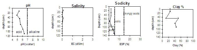
Key Profile Characteristics
pH | Salinity Rating | |||
Surface (A1 horizon) | Strongly Acid | Very Low | Non-Sodic | None |
Subsoil (B21c horizon) | Strongly Acid | Very Low | Non-Sodic | None |
Deeper subsoil (at 70-110 cm) | Slightly Acid | Very Low | Non-Sodic | None1 |
 |
Horizon | Horizon Depth (cm) | pH (water) | pH (CaCl2) | EC dS/m | Exchangeable Aluminium ppm | Exchangeable Acididty meq/100g | Exchangeable Cations | Coarse Sand (0.2-2.0 mm) % | Fine Sand (0.02-0.2 mm) % | Silt (0.002-0.02 mm) % | Clay (<0.002 mm) % | Field Capacity % w/w | Wilting Point % w/w | |||
Ca | Mg | K | Na | |||||||||||||
meq/100g | ||||||||||||||||
A1 | 0-12 | 5.3 | 4.5 | 0.07 | 39 | 9.2 | 1.2 | 0.76 | 0.51 | 0.23 | 6 | 63 | 5 | 25 | 22.1 | 4.7 |
A2 | 12-30 | 4.9 | 4.3 | <0.05 | 85 | 6.5 | 0.34 | 0.32 | 0.15 | 0.14 | 16 | 54 | 16 | 12 | 20.7 | 4.1 |
B21 | 30-45 | 5.4 | 4.8 | 0.06 | 44 | 9.9 | 2.4 | 3 | 0.13 | 0.27 | 3 | 29 | 13 | 52 | 31.8 | 16.5 |
B22 | 45-70 | 5.6 | 5.1 | <0.05 | 18 | 10 | 0.87 | 6.1 | 0.18 | 0.24 | 2 | 28 | 0 | 41 | 35.4 | 17.7 |
B23 | 70-90 | 6.1 | 5.3 | <0.05 | <10 | 9.3 | 0.55 | 7.7 | 0.30 | 0.39 | 4 | 33 | 17 | 45 | 35.9 | 16.2 |
B24 | 90-110 | 6.3 | 5.3 | <0.05 | <10 | 6.7 | 0.53 | 8.7 | 0.27 | 0.66 | 30.5 | 11.2 | ||||
B/C | 110-130 | 6.5 | 6.3 | <0.05 | 6.0 | 0.27 | 12 | 0.28 | 0.90 | |||||||
Management Considerations:
- The levels of exchangeable calcium in much of the deeper subsoil (from 70 cm depth) are very low compared to levels of exchangeable magnesium (i.e. magnesic). This indicates that nutrient imbalance may occur (e.g. calcium deficiency).
- The upper subsoil is non-sodic and well structured (parting to fine blocky shaped peds). This will provide few restrictions to root and water movement in the subsoil The deeper subsoil becomes strongly magnesic and coarser structured (with some dispersion occurring after remoulding) which will restrict root and water movement to a larger degree.
© State of Victoria (Agriculture Victoria) 1996 - .

This work, Victorian Resources Online, is licensed under a Creative Commons Attribution 4.0 licence. You are free to re-use the work under that licence, on the condition that you credit the State of Victoria (Agriculture Victoria) as author, indicate if changes were made and comply with the other licence terms.
The licence does not apply to ‘branding’ or some ‘images or photographs’ that may be owned by third parties. We ask you to seek prior approval to use images using the VRO feedback form. Access to higher quality images can also be provided on request.
This page was last updated on .