
Staughton Hill Complex
|
This information has been obtained from the report: Eruption Points of the Newer Volcanic Province of Victoria by Neville Rosengren. This report was published in 1994 and was prepared for the National Trust of Australia (Victoria) and the Geological Society of Australia (Victorian Division). The review of eruption points was based on an earlier unpublished manuscript Catalogue of the post-Miocene volcanoes of Victoria compiled by O P Singleton and E B Joyce (Geology Department, University of Melbourne 1970). |
| Location: | 38 20 00S 142 55 00E (external link); 7421-2-1 (Dixie) 671558. 9 km S of Terang. Timboon - Terang Road, Heytesbury. | 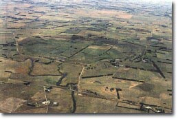 Staughton Hill volcanic complex. |
Land Tenure/Use: | Private land. Agriculture and grazing, small quarries, exposure in dams and cuttings. | |
Type 8: | Tuff ring and maar crater with multiple scoria eruption points. | |
This is a large and complex site and displays several modes of volcanic eruption. It comprises a maar crater which now contains a drained lake (Keayang Swamp) and is surrounded by a tuff ring, three broad scoria and lava mounds (Staughton Hill, McCunnies Hill and Dixie Hill), a deep circular crater (Lake Mumblin) surrounded by a rim of welded lava spatter and a group of small, possible eruption points on the south-western slopes of Staughton Hill. The complex rests on a roughly triangular block of Tertiary limestone that may have been uplifted contemporaneously with the volcanic activity. The broad maar forming Keayang Swamp has cut into the western corner of the uplifted limestone. The surrounding tuff ring is breached on the western side by Mount Emu Creek. There is a thick exposure of basalt in the rim of Keayang Swamp. The later volcanic events occurred adjacent to, rather than inside, the maar and may not be related to it. | ||
The lava and spatter cone that surrounds the crater containing Lake Mumblin is 400 m diameter and displays a variety of cooling lava features such as ropy lava. This inner crater lies in a broader remnant crater which may predate the formation of Keayang Swamp maar. Lake Mumblin has a cone-shaped floor to 12 m depth. The scoria mounds have broad flattened summits with no obvious craters and are partly capped by basalt flows. The interpretation of the volcanic topography and sequence is complicated by the presence of sinkholes in the limestone which have the appearance of small volcanic craters. | ||
190 m; 75 m. | ||
State: | The site reveals a variety of juxtaposed but not necessarily related volcanic events that occurred in close time proximity. The breaching of the maar crater by stream action is an unusual event in the Newer Volcanics Province. Lake Mumblin is the best example of a deep, circular lake-filled crater with a spatter rampart. The whole site presents a diverse array of geological and geomorphological features. | |
Class 2: | The site has been substantially disturbed. Keayang Swamp has been drained and a deep, vertical lava vent on Dixie Hill has been deliberately filled with rock (Edwards 1991d). Despite this, the broad pattern of volcanic and other geological processes is evident. Removal or damage to remaining volcanic features such as the spatter rim at Lake Mumblin, should be prevented. The nature and thickness of the sedimentary fill at Keayang Swamp and Lake Mumblin is unknown and it is likely to contain material important in reconstructing vegetation and climatic history. | |
References: | Ollier, C.D. & Joyce, E.B. 1964. Volcanic physiography of the Western Plains of Victoria. Proceedings of the Royal Society of Victoria 77, pp 357-376. Ollier, C.D. 1967a. Landforms of the Newer Volcanic Province of Victoria. In J.N. Jennings & J.A. Mabbutt (eds). Landform studies from Australia and New Guinea. ANU Press. pp. 315-339. Ollier , C.D.1967b. Maars: their characteristics, varieties and definition. Bulletin volcanologique 31, pp. 45-73. Joyce, E.B. 1975. Quaternary volcanism and tectonics in southeastern Australia. In R.P Suggate & M.M. Cresswell (eds) Quaternary Studies. Royal Society of New Zealand Bulletin 13, pp. 169-176. Edwards, J. 1991b. Geology of the Cudgee 1:25 000 map, Port Campbell Embayment, East Otway Basin, Victoria. Geological Survey of Victoria Unpublished Report 1991/7. | |
© State of Victoria (Agriculture Victoria) 1996 - .

This work, Victorian Resources Online, is licensed under a Creative Commons Attribution 4.0 licence. You are free to re-use the work under that licence, on the condition that you credit the State of Victoria (Agriculture Victoria) as author, indicate if changes were made and comply with the other licence terms.
The licence does not apply to ‘branding’ or some ‘images or photographs’ that may be owned by third parties. We ask you to seek prior approval to use images using the VRO feedback form. Access to higher quality images can also be provided on request.
This page was last updated on .