
Sodosols
| Sodosols have a strong texture contrast between surface (A) horizons and subsoil (B) horizons and the subsoil horizons are sodic. Using the Australian Soil Classification, Sodosols can be grouped further (Suborder) based on the colour of the upper 20 cm of the subsoil i.e. red, brown, yellow, grey and black. These can be further differentiated based on subsoil characteristics (Great Groups) such as the level of sodicity (in the upper B horizon) and the presence of carbonate or lime (Subgroup). Sodosols are widespread in the Goulburn-Broken Catchment Management Region. However, they are generally found on the extensive Riverine Plains north of the uplands (and the Hume Highway) and the low hills and rises east of Heathcote. Surface soil textures and depth vary considerably and have significant implications for management; affecting soil workability, permeability, crop establishment, moisture availability and erodibility. The subsoils are sodic and the yellow, grey and brown Suborders in particular, are generally quite dense and coarsely structured, characterised by coarse prismatic, columnar or blocky peds. They also disperse when wet, resulting in restricted root and water movement through the profile. | 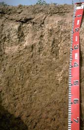 Brown Sodosol near Dookie |
| Sodosols in the Goulburn Broken Region This broad scale map presents an overview and should only be used as a general indication of the distribution of Sodosols in the Goulburn Broken Region. It shows areas where Sodosols are most likely to occur within the region. Note that other soil types may also occur within these mapped areas although they are likely to be a more minor component. | 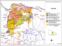 Sodosols in the Goulburn Broken Region |
| This map has been developed from work done by DPI's former Centre for Land Protection Research as part of the Goulburn Broken Dryland Regional Development Project. This work utilised existing surveys, remote sensing information and some additional field work to develop an updated 1:100 000 soil/landform coverage across the region. Soils are difficult to map at this broad scale because of their diversity. Even in relatively small areas, a number of soils may occur which relate to differences in topography and landscape position. Variation in some of the major soil profile properties can also occur within these mapped areas. Any agricultural enterprise should be based on a proper on-site assessment of the soil and landscape. A number of soil surveys have been completed in this region at varying scales and intensity. However, in some areas very little soil survey has taken place (see the Soil and Land Survey Director). | |
Sodosols (in association with Vertosols) are common on the older alluvial plains of the region. These plains were often traversed by prior streams. The Red Sodosols are the most permeable of the Sodosols in the region and tend to occur in the slightly higher and therefore better drained topographic positions compared to their brown, yellow and grey counterparts.
Red Sodosols
Some Red Sodosols have been formerly known by local names such as Lemnos loam in the irrigation surveys of the 1940’s, 50’s and 60’s. These soils are found principally in the higher landscape positions on the plains and occasionally on the low hills and rises. On the plains, particularly east of Shepparton, Red Sodosols are the upper most soil type of a prior stream sequence with Brown and Grey Sodosols occurring below. However, the relative relief is very low and in many cases laser levelling obscures the soil. In some places the subsoil may not be sodic enough for a Sodosol classification and therefore is classified as a Red Chromosol. Depth to the subsoil also can vary across areas. Surface texture also varies and is sandier and deeper in some areas, particularly when associated with the Red Chromosols of the Devenish area.
Brown and Yellow Sodosols
As part of the prior stream system, the Brown Sodosols generally occur lower in the landscape and equate with Goulburn loam and Goulburn clay loam soil types on the older irrigation surveys. The Brown and Yellow Sodosols are associated with less permeable situations, although some Brown Sodosols may be whole coloured and strongly structured and only slightly less workable than the Red Sodosols. However, most of the Brown and Yellow Sodosols are mottled, indicating restricted drainage. Again depth to subsoil varies. Generally the surface horizons are coarser (sandier) and deeper when closer to the uplands and associated with drainage lines. When these soils occur on solid geology (sedimentary low hills and rises) they are associated with salinity and prone to gully and tunnel erosion with numerous saline seeps. There are also varying amounts of buckshot gravel (ironstone nodules) associated with these soil types.
Grey and Black Sodosols
Grey and Black Sodosols are also associated with the lower terrain and poorer situations. In the Euroa area the subsoils can be vertic and depending on the shallowness of the surface (A) horizons, could also be regarded as Vertosols.

© The State of Victoria, 1996 - .
This page was last updated on .