
Hydrosols
Like Vertosols, Hydrosols occupy depressions or anywhere water is likely to accumulate. Their main characteristic is seasonal saturation rather than specific soil characteristics. In the Australian Soil Classification Hydrosols can be distinguished (into Suborders) by their degree of saturation, either by marine or non-marine water. Generally Hydrosols are defined by at least three months saturation, so often mapping is difficult if there is little knowledge of the area and soils are classified into other Orders.
In the Goulburn-Broken Catchment Management Authority (CMA) Hydrosols generally occur on the Riverine Plains in the Lake Cooper and Lake Mokoan areas and other smaller swamps.
| Hydrosols in the Goulburn Broken Region This broad scale map presents an overview and should only be used as a general indication of the distribution of Hydrosols in the Goulburn Broken Region. It shows areas where Sodosols are most likely to occur within the region. Note that other soil types may also occur within these mapped areas although they are likely to be a more minor component. | 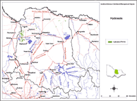 Hydrosols in the Goulburn Broken Region |
| This map has been developed from work done by DPI's former Centre for Land Protection Research as part of the Goulburn Broken Dryland Regional Development Project. This work utilised existing surveys, remote sensing information and some additional field work to develop an updated 1:100 000 soil/landform coverage across the region. Soils are difficult to map at this broad scale because of their diversity. Even in relatively small areas, a number of soils may occur which relate to differences in topography and landscape position. Variation in some of the major soil profile properties can also occur within these mapped areas. Any agricultural enterprise should be based on a proper on-site assessment of the soil and landscape. A number of soil surveys have been completed in this region at varying scales and intensity. However, in some areas very little soil survey has taken place (refer to the Soil and Land Survey Directory). | |

© The State of Victoria, 1996 - .
This page was last updated on .