
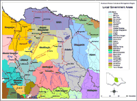
Local Government
There are a total of twelve Local Government Areas that have some coverage within the Goulburn Broken Region.
These include:
| Local Governments who have a major area within the Goulburn Broken Region. Moira Shire website (external link) Shire of Campaspe website (external link) City of Greater Shepparton website (external link) Shire of Strathbogie website (external link) Mitchell Shire Council website (external link) Shire of Murrindindi website (external link) Local Governments who have a minor area within the Goulburn Broken Region. Rural City of Wangaratta website (external link) Shire of Yarra Ranges website (external link) Wellington Shire Council website (external link) City of Greater Bendigo website (external link) Macedon Ranges Shire Council website (external link) | 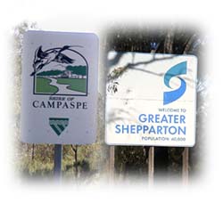 |
|
The Local Government Areas map is intended to show the relative areas and boundaries of each council located within and outside the region. Data to create this map was derived from the Local Government Area layer (L100) of the Department of Natural Resources and Environment's Corporate Geospatial Data Library. This layer describes the post amalgamation LGA boundaries as defined by the Department of Finance. Place names (i.e. towns) are provided by Vicroads and AUSLIG. |

© The State of Victoria, 1996 - .
This page was last updated on .