
Public Land
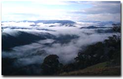 Alpine National Park | Public land covers about 28% of the Goulburn Broken Region - in the form of State, National and Regional Parks, reserves, wilderness areas, Commonwealth land and conservation areas. Public land consists primarily of land that is less suitable for agriculture due mainly to its landform (GBCMA, 1997). Much of the public land is covered with remnant vegetation and is a very important natural resource. |
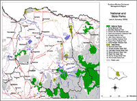 Public Land and Parks in the Goulburn Broken Region | This map shows the location of State and National Parks in the Goulburn Broken region, and in nearby regions (as at January 2004). Parks Victoria manages Victoria's world class network of national, state, regional and metropolitan parks, other conservation reserves, many significant cultural assets, and Melbourne's bays and major waterways. The Parks Victoria Parkweb website (external link) provides information about each of Victoria's National and State Parks. |

© The State of Victoria, 1996 - .
This page was last updated on .