
GN17
| Group: Nagambie Landcare Group | Australian Soil Classification: Bleached, Eutrophic, Red CHROMOSOL; clay loamy / clayey |
| Northcote Factual Key: Dr 2.41 | Great Soil Group: red podzolic |
| General Landscape Description: Slight rise on an old alluvial plain. Original vegetation included Yellow Box (Eucalyptus melliodora) and Grey Box (E. microcarpa). This area is believed to represent the primary flood plain of the Goulburn River (Skidmore 1993). | |
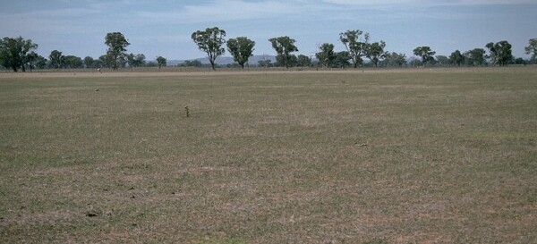 GN17 Landscape |
Soil Profile Morphology
Surface Soil
| A1 | 0-13 cm | Strong brown (7.5YR4/6); fine sandy clay loam; hardsetting; weak to moderately structured; very firm consistence dry; pH 5.6; abrupt change to: | 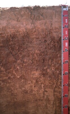 GN17 Profile |
| A2 | 13-17 cm | Yellowish red (5YR5/6) conspicuously bleached (5YR7/4d); light fine sandy clay loam; very firm consistence dry; pH 5.5; clear and wavy change to: | |
| A3 | 17-20 cm | Yellowish red (5YR5/8); fine sandy clay loam; firm consistence dry; pH 5.8; clear and wavy change to: | |
| Subsoil | |||
| B21 | 20-30 cm | Red (2.5YR4/8); light medium clay; moderate to strong medium polyhedral structure; very firm consistence moist; pH 6.4; gradual and wavy change to: | |
| B22 | 30-50 cm | Red (2.5YR4/6); light medium clay; strong medium polyhedral structure (with smooth faced peds); strong consistence dry; pH 6.2; gradual and wavy change to: | |
| B31 | 50-70 cm | Yellowish red (5YR5/8); clay loam (fine sandy); moderate coarse prismatic, breaking down to strong coarse blocky and moderate medium polyhedral structure; strong consistence dry; pH 6.0; gradual and wavy change to: | |
| B32 | 70-100 cm | Yellowish red (5YR5/8); fine sandy clay loam; weak coarse prismatic structure; strong consistence dry; gradual and wavy change to: | |
| B33 | 100+ cm | Strong brown (7.5YR5/6); fine sandy clay loam; weak consistence dry. | |
| Note: This soil occurs within the Tabilk Red Soils soil/geomorphic unit as described by Skidmore (1993). | |||
Key Profile Features
- Strong texture contrast between surface (A) horizon (clay content 15-24%) and subsoil (B21) horizon (clay content 46%).
- Hardsetting surface horizons.
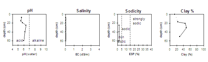
Key Profile Characteristics
pH | Salinity Rating | |||
Surface (A1 horizon) | moderately acid | very low | non-sodic | slaking, no dispersion |
Subsoil (B21 horizon) | slightly acid | very low | non-sodic | none |
Deeper subsoil (at 0.6 m) | moderately acid | very low | non-sodic | none |
 |
Management Considerations:
Whole Profile
- Plant Available Water Capacity is medium (estimated at 102mm) for this profile - based on the laboratory data available.
Surface (A) Horizons
- The surface horizon is hardsetting and has a high fine sand (52%) and silt (32%) content. When cultivated in a dry condition these soils will become “powdery” and subsequent rain may form a surface crust. Cultivation of these soils when wet may result in surface sealing upon drying. Practices such as minimum tillage, stubble retention and pasture rotation should be encouraged. Such management techniques assist in building up soil organic matter and reducing aggregate slaking.
- Subsurface (A2 and A3) horizons disperse slightly after remoulding. This indicates that the soils may disperse slightly if over-cultivated or overstocked when wet. This could result in some structural degradation (eg. cultivation pan development).
- The overall nutrient status of the surface soils is very low.
- The moderately acid surface soil indicates that there is some potential for aluminium and manganese toxicity to occur. A lime test (sampled at the paddock level) may be appropriate to determine whether lime is needed to raise pH levels.
- Organic carbon and total nitrogen levels are satisfactory. It is worth noting that Site GN18 in an adjacent paddock, (never been cropped) has a slightly higher level of nitrogen and organic carbon.
- The surface soil has a relatively high plant available water holding capacity based on the laboratory data. Overall plant available water holding capacity for the profile will be relatively high as the subsoil is non-sodic and non saline.
- The subsoil is non-sodic throughout - a favourable condition which should result in adequate water and root movement through the upper subsoil.
- From 50 cm depth in the profile, the calcium:magnesium ratio becomes low. This may result in conditions which will restrict root and water movement at depth.
- The overall nutrient status is low in the subsoil.
- The pH levels have increased in the subsoil and are within the preferred pH range of 6.0-7.5.
Comments from Landholder:
- This soil is representative of the area between Murchison and Tabilk.
- Wheat and oats cropped on a 5-6 year rotation. Also suitable for lucerne and vineyards.

© The State of Victoria, 1996 - .
This page was last updated on .