
GN12
| Location: Dookie Agricultural College. | |
| Australian Soil Classificiation: Eutrophic, Mesonatric, Brown SODOSOL. | Great Soil Group: solodized solonetz/solodic. |
| Geology: Quaternary alluvium | General Landscape Description: Broad depression on plain. |
| Soil Mapping Unit: Nalinga Loam (Downes, 1949). | |
| Occurrence: Generally found in the outskirts of the Land Management Group area on flat, undulating to rising country. | |
| Site Description: Grazing paddock. | |
| Native Vegetation: Yellow box (Eucalyptus melliodora) and White cypress pine/Murray pine (Callitris columellaris) are found growing on this soil and Grey box (Eucalyptus microcarpa) are found on the heavier textured sites. | |
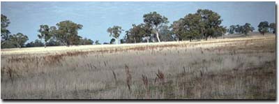 Site GN12 Landscape |
Soil Profile Morphology:
Surface Soil
| A1 | 0-10 cm | Dark yellowish brown (10YR3/4); silty clay loam; rusty root channel mottling; massive; strong consistence (dry); very few (< 2%) iron segregations (1 cm); pH 5.3; sharp and smooth change to: | 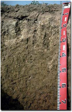 Site GN12 Profile |
| Subsoil | |||
| B1 | 10-20 cm | Greyish brown (10YR5/2); sporadically bleached; clay loam (fine sandy) capping, becoming clay; moderate very coarse columnar structure; very strong consistence (dry); strongly cemented; many (25%) iron segregations; pH 7.1; sharp and wavy change to: | |
| B21 | 20-35 cm | Yellowish brown (10YR5/4); with surface (A) infil between ped faces; medium clay; moderate medium prismatic, parting to moderate coarse blocky structure; very strong consistence (moist); pH 7.8; clear change to: | |
| B22 | 35-60 cm | Yellowish brown (10YR5/4) with diffuse yellowish brown (10YR5/6) mottles; medium heavy clay; firm consistence (moist); soft fine (1-3 mm size) manganiferous segregations are common (15%) ; pH 8.4; clear change to: | |
| B23 | 60-80 cm | Red (5YR5/6 and 5YR4/6); medium clay; firm consistence (moist); very few (2%) dark hard and round soft nodules (1-2 mm); pH 8.6; clear change to: | |
| B24 | 80+ cm | Red (5YR4/6 and 5YR5/6); light medium clay; weak consistence (moist); ferromanganiferous segregations (5 mm to 1 cm size) common; few coarse fragments from parent rock (4 cm). | |
Key Profile Features:
- Strong texture contrast between surface (A) horizon and subsoil (B21 horizon).
- Columnar structure in upper subsoil.
pH | Salinity Rating | |||
Surface soil (A1 horizon) | Strongly Acid | Very Low | Non-Sodic | None |
Upper subsoil (20 - 35 cm) | Slightly Alkaline | Very Low | Strongly Sodic | Complete |
Deeper subsoil (at 80+ cm) | Strongly Alkaline | Low | Strongly Sodic | Complete |
 |  |  |  |
Horizon | Horizon Depth (cm) | pH (water) | pH (CaCl2) | EC 1:5 | Exchangeable Cations | Exch. Al mg/kg | Exch. Acidity meq/100g | Field Capacity pF 2.5 | Wilting Point pF 4.2 | Coarse Sand (0.2 -2 mm) | Fine Sand (0.02 -0.2 mm) | Silt (0.002 -0.02 mm) | Clay (<0.002 mm) | |||
Ca | Mg | K | Na | |||||||||||||
meq/100g | ||||||||||||||||
A1 | 0-10 | 5.3 | 4.4 | 0.10 | 4.0 | 2.0 | 0.6 | 0.2 | 35 | 11 | 29.1 | 9 | 2.5 | 37.2 | 31.0 | 26.0 |
B1 | 10-20 | 7.1 | 5.6 | 0.06 | 3.8 | 3.7 | 0.5 | 1.4 | <10 | 4.6 | 22.5 | 10.3 | 3.2 | 35.2 | 31.0 | 29.0 |
B21 | 20-35 | 7.8 | 6.6 | 0.13 | 4.6 | 6.0 | 0.6 | 2.5 | <10 | 3.9 | 26.3 | 13.4 | 1.1 | 32.2 | 24.5 | 38.5 |
B22 | 35-60 | 8.4 | 7.2 | 0.25 | 5.2 | 8.5 | 0.7 | 3.7 | ||||||||
B23 | 60-80 | 8.6 | 7.4 | 0.31 | 4.5 | 8.9 | 0.7 | 4.2 | ||||||||
B24 | 80+ | 8.8 | 7.6 | 0.28 | 3.3 | 7.3 | 0.6 | 3.9 | ||||||||
Management Considerations (Briggs 1995):
Favourable Characteristics
- Fertility - Both sulphur and organic matter levels are high in the topsoil. Some applied phosphorus should be available to crops and pastures.
- Workability/Trafficability - The surface soil is relatively easy to cultivate but has the tendency to be abrasive on machinery due to rocks and the sandy texture of the soil.
- Acidity/Alkalinity - This soil has a strongly acidic topsoil (with relatively higher aluminium levels than for less acidic surface soils) that rapidly becomes neutral to alkaline at depth. These soils have a reasonable ability to resist further acidification.
- Drainage - This soil drains well until the profile becomes saturated. The strongly sodic and dipsersive clay subsoil will significantly restrict root and water movement down the profile. Waterlogging can commonly occur after heavy rains.
- Soil Structure - This soil requires careful management to maintain its soil structure. With overcultivation the soil structure will decline and show signs of running together when wet and set hard when dry. Care should be taken to avoid cultivation of these soils when moist to wet as structural degradation is likely to occur.
- This soil is considered to be less productive than the 'Dookie red' and 'black self-mulching soil' It also requires more fertiliser to keep the nutrient level at a reasonable level. Direct drilling is a feasible option which will help maintain the soil structure.
- Current Possibilities - Wheat, oats, triticale, barley, lupins (if not too wet).
- Further Possibilities - Linola.
- The soil grows better pastures than crops. A good pasture phase is also required (more so than with heavier soils) to improve soil fertility. Deeper rooted perennials may be able to tap into subsoil moisture, increasing productivity and nutrient status as well as decreasing groundwater recharge.
- Current Possibilities - Phalaris (Australian Holdfast, Sirosa mix), Trikkala, Goulburn, Seaton Park, Cocksfoot (if drainage is suitable).
References:
Management Considerations based on booklet: ' Soil Management Units in the Dookie Land Management Group Area' - compiled by Suzanne Briggs. Agriculture Victoria,1995.
Downes R.G. (1949). 'Soil, Land-Use, and Erosion Survey around Dookie, Victoria' , Bulletin 243, CSIRO, Victoria.
Profile Described By: Mark Imhof, John Martin and Sonia Thompson (4/5/94).

© The State of Victoria, 1996 - .
This page was last updated on .