
GN32
| Location: Girgarre | |
| Aust. Soil Class: Epihypersodic, Epipedal, Brown VERTOSOL |
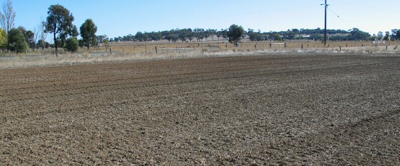 GN32 Landscape |
Soil Profile Morphology
Surface Soil
| A1 | 0-10 cm | Brown (10YR4/3); light clay; moderate-strong coarse to medium polyhedral structure; strong consistence (dry); hard surface condition; surface cracking; pH 5.8; abrupt change to: | 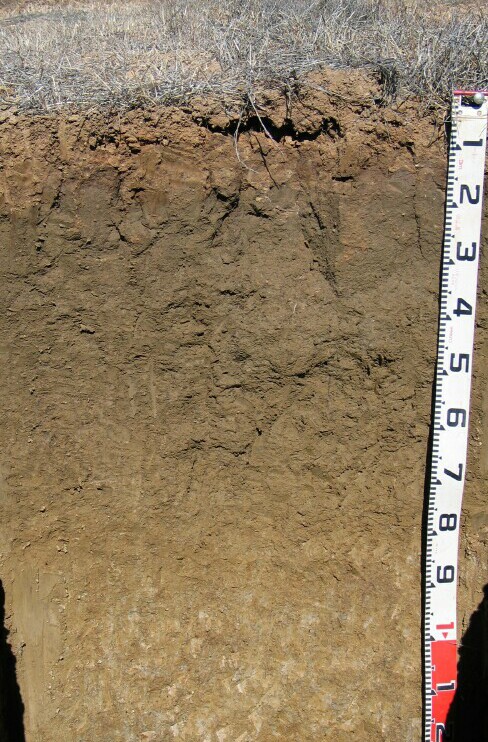 GN32 Profile |
| Subsoil | |||
| B21 | 10-35 cm | Greyish brown to brown (10YR5/2 & 5/3) with diffuse yellowish brown (10YR5/6) mottles; medium clay; moderate very coarse prismatic structure; very strong consistence (slightly moist); some dark staining along prism faces; pH 7.3; clear change to: | |
| B22 | 35-80 cm | Light olive brown (2.5Y5/3); medium heavy clay; strong fine to very fine lenticular structure; firm consistence (moist); few (10%) dark manganese stains in patches; pH 8.6; gradual change to: | |
| B23 | 80-120 cm | Light olive brown to light yellowish brown (2.5Y5/3 & 6/3); light clay; lenticular structure; weak consistence (moist); pH 8.6; clear change to: | |
| B24 | 120-150 cm | Light brownish grey (10YR6/2) with very many (50%) yellow and brownish yellow (10YR8/6 & 6/8) mottles; light medium clay; coarse to medium lenticular, parting to strong medium subangular blocky and strong fine to very fine polyhedral structure; manganese stains; pH 8.4. | |
Key Profile Features
- Clay texture throughout profile.
- Vertic properties (i.e. as evidenced by lenticular structure)
- Surface cracking when dry.
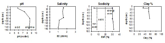
pH | Salinity Rating | |||
Surface (A1 horizon) | Moderately Acid | Extremely High | Non-Sodic | None |
Subsoil (B21 horizon) | Strongly Alkaline | Extremely High | Strongly Sodic | None1 |
Deeper subsoil (at 120-150 cm) | Moderately Alkaline | Extremely High | Strongly Sodic | Moderate |
 |
Horizon | Horizon Depth | pH (water) | pH CaCl2 | EC 1:5 | Exchangeable Cations | ||||
Ca | Mg | K | Na | ||||||
meq/100g | |||||||||
A1 | 0-10 | 5.8 | 5.5 | 1.6 | 0.43 | 4.6 | 5.8 | 0.5 | 0.8 |
B21 | 10-35 | 7.3 | 7.3 | 1.5 | 0.35 | 6.3 | 10 | 0.8 | 7.2 |
B22 | 35-80 | 8.6 | 8.6 | 1.6 | 0.35 | 6.3 | 13 | 0.9 | 8.5 |
B23 | 80-120 | 8.6 | 8.6 | 1.1 | 0.21 | 3.6 | 9 | 0.5 | 5.8 |
B24 | 120-150 | 8.4 | 7.8 | 0.20 | 3.9 | 9.9 | 0.6 | 6.5 | |
Horizon | Horizon Depth | Ex Al mg/kg | Ex Ac meq/100g | Field pF2.5 | Wilting Point pF4.2 | Coarse Sand (0.2-2.0mm) | Fine Sand (0.02-0.2mm) | Silt (0.002-0.02mm) | Clay (<0.002mm) |
A1 | 0-10 | 7.5 | 28.3 | 15.1 | 3 | 33 | 2 | 34 | |
B21 | 10-35 | 33.1 | 16.8 | 1 | 21 | 26 | 54 | ||
B22 | 35-80 | 38.4 | 18.3 | 1 | 15 | 23 | 57 | ||
B23 | 80-120 | 31.3 | 14.5 | ||||||
B24 | 120-150 |
Management Considerations;
Whole Profile
- The whole profile has a very high level of soluble salts throughout. This will significantly affect the growth of salt-sensitive species.
- The water table is also likely to rise into the upper soil profile during wet seasons – evidenced by grey and yellow mottling at depth and managnese staining in patches. This will create another constraint to the growth of waterlogging-intolerant species.
- The soil profile displays strong vertic features (i.e. cracking and development of lenticular peds) which indicates that significant shrinking and swelling occurs during wetting and drying cycles.
- The coarsely structure upper subsoil is strongly sodic which will restrict root growth. However, dispersion only occurs after remoulding – due to the effect of the high level of soluble salts restricting dispersion. This is likely to limit the restriction to water movement that such high levels of sodicity would normally impose.

© The State of Victoria, 1996 - .
This page was last updated on .