
GN36
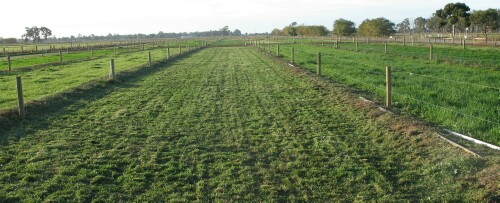
Location: Kyabram
Australian Soil Classification: Vertic, Calcic, Red CHROMOSOL * (Former gypsum site)
Great Soil Group: Red-brown Earth
Northcote Factual Key: Dr
General Landscape Description: Level plain (with prior streams).
Site Description: Kyabram Research Farm, pasture trials (Bay 0). Former gypsum site.
Geology: Quaternary prior stream deposits (Shepparton Formation).
| ||
Surface Soil
| A11 | 0-10 cm | Brown (7.5YR4/4); fine sandy clay loam; weak-moderate coarse blocky, parting to medium blocky structure; very firm consistence dry; pH 6.6; clear change to: | 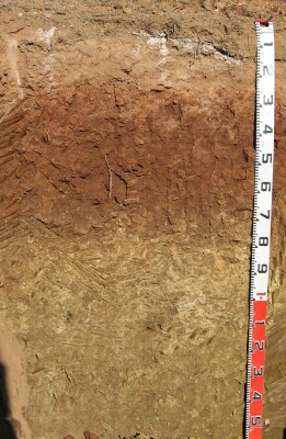 GN36 Profile |
| A12 | 10-16 cm | Reddish brown (5YR4/4); fine sandy clay loam; moderate coarse sub-angular blocky, parting to strong fine to very fine polyhedral structure; very firm consistence dry; pH 6.4; abrupt change to: | |
| Subsoil | |||
| B21 | 16-55 cm | Dark red (2.5YR4/8); heavy clay; weak prismatic, parting to strong coarse blocky, parting to moderate medium sub-angular blocky structure; shiny ped faces; some slickensides and cracking present; strong consistence dry; macropores common; roots visible; pH 7.1; gradual change to: | |
| B22 | 55-80 cm | Reddish brown (5YR4/4); medium heavy clay; strong consistence slightly moist; slickensides present; pH 8.0; clear change to: | |
| B31 | 80-110 cm | Yellowish brown (10YR5/4); medium heavy clay (fine sandy); moderate strong blocky, parting to moderate medium to fine sub-angular blocky structure; strong to very strong consistence moist; few (2%) carbonate nodules (2-4 mm in size) as well as soft carbonate; pH 8.6; gradual change to: | |
| B32 | 110-150 cm | Yellowish brown (10YR5/4) with red (2.5YR5/6) mottles; few (5%) variable soft coarse (6-8 mm) manganese segregations; pH 9.0. | |
Soil Profile Characteristics:
pH | Salinity Rating | |||
Surface Soil (A11 horizon) | Slightly Acid | Very Low | Non-Sodic | None |
Upper Subsoil (B21 horizon) | Slightly Alkaline | Very Low | Non-Sodic | None |
Deep Subsoil (at 110-150 cm) | Very Strongly Alkaline | Very Low | Sodic | Strong-Complete |
Horizon | Horizon Depth (cm) | pH (water) | pH (CaCl2) | EC dS/m | Sodium Chloride % | Exchangeable Cations | |||
Ca | Mg | K | Na | ||||||
meq/100g | |||||||||
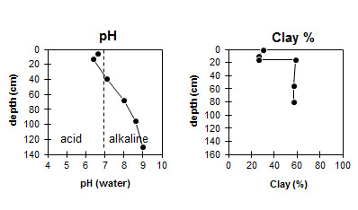
A11 | 0-10 | 6.6 | 6.1 | 1.4 * | <0.01 | 14 * | 1.2 | 0.6 | <0.01 |
A12 | 10-16 | 6.4 | 6.1 | 0.83 * | <0.01 | 9.7 * | 0.8 | 0.5 | <0.01 |
B21 | 16-55 | 7.1 | 7.1 | 0.70 * | <0.01 | 11 * | 7.3 | 0.7 | 0.3 |
B22 | 55-80 | 8.0 | 8.0 | 0.66 * | 0.01 | 10 * | 15 | 0.8 | 2.4 |
B31 | 80-110 | 8.6 | 8.1 | 0.74 * | 5.0 * | 15 | 0.6 | 4.6 | |
B32 | 110-150 | 9.0 | 8.9 | 0.14 * | 5.1 * | 13 | 0.84 | 3.6 | |
NOTE: * Former gypsum site so the chemistry will not be representative of a typical soil profile in this area.
Horizon | Horizon Depth (cm) | Organic Carbon % | Nitrogen % | Exchangeable Aluminium (KCL) mg/kg | Exchangeable Acidity meq/100g | Field Capacity pF 2.5 | Wilting Point pF 4.2 | Coarse Sand (0.2-2.0 mm) | Fine Sand (0.02-0.2 mm) | Silt (0.002-0.02 mm) | Clay (<0.002 mm) |
A11 | 0-10 | 2.3 | 0.16 | 3.6 | 31.3 | 22.0 | 2 | 29 | 35 | 31 | |
A12 | 10-16 | <10 | 3.0 | 24.8 | 14.6 | 1 | 32 | 37 | 26 | ||
B21 | 16-55 | 2.9 | 32.1 | 18.6 | 0 | 13 | 13 | 59 | |||
B22 | 55-80 | <1.0 | 34.0 | 19.1 | 0 | 10 | 25 | 57 | |||
B31 | 80-110 | ||||||||||
B32 | 110-150 |
Profile Described By: Mark Imhof, Austin Brown, Nathan Robinson and Sonia Thompson (June 2005).

© The State of Victoria, 1996 - .
This page was last updated on .