
GN26
| Location: East Shepparton Landcare Group. | Australian Soil Classification: Haplic, Calcic, Red CHROMOSOL. |
| Northcote Factual Key: Dy 2.13 | Great Soil Group: red-brown earth |
| General Landscape Description: Level plain with prior stream activity. This site has been mapped as Goulburn Loam by Skene and Freedman (1944). Apples are currently grown here. | |
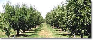 Site GN26 Landscape |
Soil Profile Morphology:
Surface Soil
| A1 | 0-17cm | Brown (7.5YR4/4); fine sandy clay loam; hardsetting surface condition; weakly structured; strong consistence dry; contains very few (1%) quartz gravels (4 mm size) and a few (4%) ironstone gravels; pH 6.0; sharp change to: | 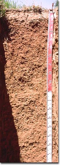 Site GN26 Profile |
| Subsoil | |||
| B21 | 17-45cm | Yellowish red (5YR4/6); medium clay; moderate coarse blocky structure; very strong consistence dry; pH 7.9; gradual change to: | |
| B22K | 45-65cm | Strong brown (7.5YR5/6); medium heavy clay; moderate coarse blocky structure; very firm consistence moist; contains a few (2-5%) soft and nodular carbonates; pH 8.1; gradual change to: | |
| B23K | 65-105cm | Strong brown (7.5YR5/6); medium clay; moderate coarse blocky structure; very firm consistence moist; contains a few (5%) soft and nodular carbonates; pH 8.3; gradual change to: | |
| B31 | 105-160cm | Yellowish brown (10YR5/6) with yellowish red (5YR5/8) mottles; medium clay; moderate medium polyhedral, parting to strong very fine polyhedral structure; firm consistence moist; contains very few (< 2%) carbonate nodules and a few (5%) manganese stains; pH 8.5; gradual change to: | |
| B32 | 160+ cm | Yellowish brown (10YR5/6); light medium clay; strong coarse polyhedral, parting to strong medium polyhedral structure; firm consistence moist; contains very few (< 2%) carbonate nodules and a few (10%) soft manganese segregations; pH 8.5. | |
- Strong texture contrast between surface (A1) horizon (20% clay) and subsoil (B21) horizon (50% clay).
pH | Salinity Rating | |||
Surface (A1 horizon) | moderately acid | very low | non-sodic | none |
Subsoil (B21 horizon) | slightly alkaline | very low | non-sodic | none |
Deeper subsoil (at 1 m) | moderately alkaline | very low | non-sodic | none |
Deeper subsoil (160+ cm) | moderately alkaline | very low | sodic | - |
Management Considerations:
Whole Profile
- Plant available water capacity (PAWC) is considered to be potentially medium-high (estimated at approximately 145 mm) for the top metre of the soil profile. The majority of tree roots observed in this pit were down to 130 cm.
- Soluble salt levels are low throughout the profile.
Surface (A) Horizons
- The surface soil has a high combined fine sand and silt content (i.e. 73%) and is hardsetting when dry. Organic matter is essential for maintaining aggregation on such soils to help prevent slaking. Organic matter can be improved by minimising cultivation, incorporating organic materials and mulching.
Subsoil (B) Horizons
- Water and plant root movement will be restricted to some degree by the coarsely structured clayey subsoil. However, it is non-sodic and has a relatively high level of exchangeable calcium relative to magnesium in the upper subsoil. These factors suggest that the soil will be better drained and allow better root proliferation than some other heavier textured soils in the area (e.g. sites GN20 and GN21).
Comments from Landholder:
- Apricots also grow well on this soil.
Profile Described By: Mark Imhof, Paul Rampant, Sonia Thompson (1996).

© The State of Victoria, 1996 - .
This page was last updated on .