
GN23
| Location: East Shepparton Landcare Group. | Australian Soil Classification: Mottled, Eutrophic, Red KANDOSOL |
| General Landscape Description: Level plain with prior stream activity. This site is associated with channel deposits of a prior stream and has been mapped as Broken Sand by Skene and Freedman (1944). Peaches are currently grown here. | |
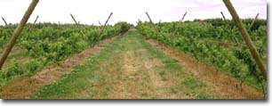 Site GN23 Landscape |
Soil Profile Morphology:
Surface Soil
| A1 | 0-8cm | Brown (7.5YR4/4) sandy loam; weakly structured; firm consistence dry; contains a few (10%) quartz gravels (4-8 mm size); pH 6.4: | 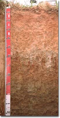 Site GN23 profile |
| B21 | 8-25cm | Dark red (2.5YR4/8) and red (2.5YR5/8) sandy clay loam; structureless; strong consistence dry; contains a common (20%) amount of quartz gravel (4-8 mm size); pH 6.4: | |
| 2A1 | 25-35cm | Yellowish red (5YR5/8) sandy loam; structureless; firm consistence dry; contains a common (15%) amount of quartz gravel (4-8 mm size); pH 6.7: | |
| 2A2 | 35-50cm | Light brown (7.5YR6/4) and reddish yellow (5YR6/8) sandy loam; structureless; firm consistence dry; contains a common (20%) amount of quartz gravel (4-8 mm size); pH 6.8: | |
| Subsoil | |||
| 2B1 | 50-85cm | Dark red (2.5YR4/8) with grey (10YR6/1) mottles coarse sandy clay loam; weakly structured; very firm consistence dry; contains a common (20%) amount of quartz gravel (4-8 mm size); pH 5.7: | |
| 2B2 | 85-95cm | Pale brown (10YR6/3) with yellowish red (5YR5/8) mottles; sandy clay loam; weakly structured; weak consistence moist; contains a few (10%) quartz gravels (4-8 mm size); pH 7.2: | |
| 2B3 | 95-130cm | Yellowish brown (10YR5/4) and strong brown (7.5YR5/8) fine sandy clay loam; weak coarse blocky, parting to moderate coarse blocky structure; weak consistence moist; contains pockets of very fine micaceous sand; pH 7.6: | |
| 2B4 | 130-140cm | Light brownish grey (10YR6/2) yellowish brown (10YR5/8); light medium clay (fine sandy) pH 7.6: | |
| 2B5 | 140cm+ | Yellowish brown (10YR5/4) with bright yellowish brown (10YR5/8) mottles fine sandy clay loam; weak consistence moist; weak coarse blocky, parting to moderate medium polyhedral structure; pH 7.7. |
- Variable textured subsoil horizons due to prior stream channel deposition.
- High coarse sand and gravel content in top metre of soil profile.
Soil Profile Characteristics:
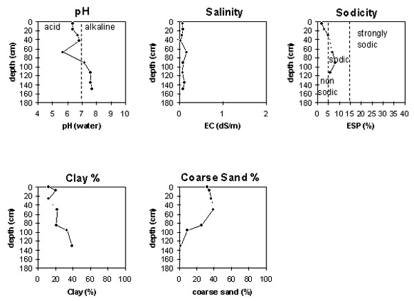
pH | Salinity Rating | |||
Surface (A1 horizon) | slightly acid | very low | non-sodic | none |
Upper subsoil (B21 horizon) | moderately acid | low | non-sodic | none |
Deeper subsoil (2B3 at 1 m) | slightly alkaline | very low | non-sodic | none |
Deep subsoil (at 140 cm) | slightly alkaline | very low | - | - |
Management Considerations:
Whole Profile
- Plant available water capacity (PAWC) is considered to be relatively low (estimated at approximately 50 mm) for the top metre of the soil profile. This is based on available laboratory data.
- Soluble salt levels are low throughout the profile.
- The high sand and gravel content in the top metre of the soil profile will ensure that infiltration and movement of water will be relatively high.
Surface (A) Horizons
- The surface soil has a high sand content (77%). Organic matter is important for maintaining aggregation on such soils, as well as for improving soil fertility and water holding capacity.
- The cation exchange capacity of the surface soils is relatively low and nutrients will be more easily leached than in the heavier textured soils.
Subsoil (B) Horizons
- The subsoil is weakly structured and has a high quartz gravel content in the upper part. It should be relatively well drained.
Comments from Landholder:
- Tractors can become bogged when wet.
Profile Described By: Mark Imhof, Paul Rampant, Sonia Thompson (1996).

© The State of Victoria, 1996 - .
This page was last updated on .