
GRES492
Location: Ensay
Australian Soil Classification: Haplic, Eutrophic, Red CHROMOSOL
Map Unit: Timbarra (previously mapped as Dargo, Component 1, but too steep for new unit definition)
Previous Site Name: AL45
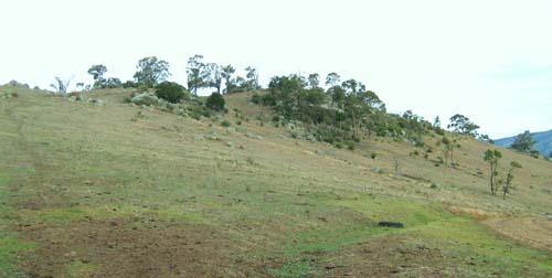
General Landscape Description: Steep low hills.
Site description: Lower east facing slope (37% slope)
Land Use: Grazing on annual pasture
Native Vegetation: Open forest
Geology: Palaeozoic granite
Soil Profile Morphology:
Surface Soil
| A11 | 0-27 cm | Dark brown (7.5YR3/2); sandy loam; apedal; hard consistence, dry; 5% granite fragments up to 8 mm; clear and wavy change to: | 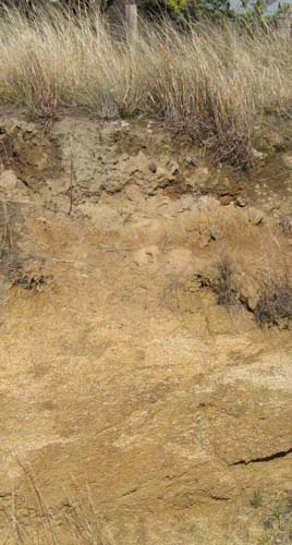 Typical shallow soil on granite south of Dargo |
| A12 | 27-50 cm | Strong brown (7.5YR5/6); gritty sandy loam; apedal; hard consistence when dry; 15% granite fragments up to 8 mm; clear and wavy change to: | |
| Subsoil | |||
| B2 | 50 -80 cm | Yellowish red (5YR5/6); sandy clay; moderate coarse (25 mm) angular blocky structure; firm consistence moist; 25% quartz and weathering feldspar crystals up to 3 mm and dark mica grains; changes to: | |
| C | 80 – 90+ cm | Strong brown (7.5YR5/6); sandy clay loam; moderate medium (20 mm) angular blocky structure; friable consistence moist; passing to weathering granite. |
Key Profile Features:
- Bordering on a gradational soil but the slight texture contrast between the surface (A) horizons and the subsoil (B) horizons makes this a borderline texture contrast soil.
Chemical and Physical Analysis:
Horizon | Horizon Depth (cm) | pH (water) | EC dS/m | Organic Carbon % | Total Nitrogen % | Exchangeable Acididty meq/100g | Exchangeable Cations | Gravel % | Coarse Sand (0.2-2.0 mm) % | Fine Sand (0.02-0.2 mm) % | Silt (0.002-0.02 mm) % | Clay (<0.002 mm) % | |||
Ca | Mg | K | Na | ||||||||||||
meq/100g | |||||||||||||||
A11 | 0-10 | 5.9 | <0.05 | 2.2 | 0.16 | 8.2 | 4.0 | 1.0 | 0.5 | 0.05 | 6 | 31 | 43 | 10 | 13 |
A11 | 10-20 | <0.05 | 12 | ||||||||||||
A12 | 30-50 | 6.7 | <0.05 | 2.2 | 4.4 | 0.8 | 0.3 | 0.08 | 22 | 37 | 42 | 11 | 11 | ||
B2 | 60-80 | 7.0 | <0.05 | 4.3 | 10.6 | 2.5 | 0.5 | 0.3 | 18 | 30 | 25 | 15 | 31 | ||
C | 80-90 | 7.1 | <0.05 | 4.8 | 11.3 | 2.9 | 0.5 | 0.4 | 5 | 29 | 27 | 14 | 28 | ||
Management Considerations
- As the soils are sandy, the plant available water capacity would be very low. However, plants would be able to utilise light rain after the soils are dry.
- Sheet and rill erosion would be high and common where the topsoil is exposed.
- Soil depth in the steep cleared drainage lines is likely to be very shallow with considerable exposed rock.
Profile Described By: J.M. Aldrick, 1978.
© State of Victoria (Agriculture Victoria) 1996 - .

This work, Victorian Resources Online, is licensed under a Creative Commons Attribution 4.0 licence. You are free to re-use the work under that licence, on the condition that you credit the State of Victoria (Agriculture Victoria) as author, indicate if changes were made and comply with the other licence terms.
The licence does not apply to ‘branding’ or some ‘images or photographs’ that may be owned by third parties. We ask you to seek prior approval to use images using the VRO feedback form. Access to higher quality images can also be provided on request.
This page was last updated on .