
GRES36
Location: Dargo
Australian Soil Classification: Acidic, Dystrophic,Brown Kandosol
Map Unit: Talbotville
Previous Site Name: AL11
General Landscape Description: Steep hills.
Site Description: North aspect (28% slope).
Land Use: Forest.
Native Vegetation: Shrubby dry forest.
Geology: Palaeozoic siltstones and shales.
Soil Profile Morphology:
Surface Soil
| A1 | 0 – 5 cm | Dark brown to brown (7.5YR4/4); gravelly clay loam; apedal; slightly hard dry; 30% small bedrock fragments up to 20 mm; pH 4.8; clear boundary to: | 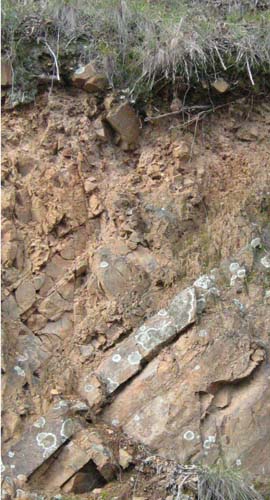 Shallow stony typical Talbotville soil profile: Cutting along Bairnsdale – Dargo Road |
Subsoil | |||
| B | 5 – 22 cm | Strong brown (7.5YR5/6); gravelly clay loam; apedal; friable, moist; 30% small bedrock fragments up to 20 mm; fragments up to 80 mm common below 10 cm; pH 5.0: | |
| R | 22+ cm | Bedrock. |
Key Profile Features:
- Soil will only support shrubby vegetation.
Chemical and Physical Analysis:
Horizon | Horizon Depth (cm) | pH (water) | EC dS/m | Organic Carbon % | Total Nitrogen % | Free Fe2O3 % w/w | Exchangeable Acididty meq/100g | Exchangeable Cations | Coarse Sand (0.2-2.0 mm) % | Fine Sand (0.02-0.2 mm) % | Silt (0.002-0.02 mm) % | Clay (<0.002 mm) % | |||
Ca | Mg | K | Na | ||||||||||||
meq/100g | |||||||||||||||
A1 | 0-5 | 4.8 | <0.05 | 3.8 | 0.19 | 2.6 | 30.5 | 0.05 | 0.09 | 0.7 | 0.07 | 18 | 18 | 31 | 19 |
B | 5-10 | 5.0 | <0.05 | 1.8 | 0.11 | 2.9 | 20.7 | <0.05 | 0.05 | 0.7 | 0.09 | 15 | 23 | 34 | 23 |
B | 10-20 | 5.0 | <0.05 | 1.8 | 0.10 | 3.3 | 21.2 | <0.05 | 0.08 | 0.7 | 0.05 | 13 | 22 | 35 | 28 |
Profile Described By: J.M. Aldrick, 1978.
© State of Victoria (Agriculture Victoria) 1996 - .

This work, Victorian Resources Online, is licensed under a Creative Commons Attribution 4.0 licence. You are free to re-use the work under that licence, on the condition that you credit the State of Victoria (Agriculture Victoria) as author, indicate if changes were made and comply with the other licence terms.
The licence does not apply to ‘branding’ or some ‘images or photographs’ that may be owned by third parties. We ask you to seek prior approval to use images using the VRO feedback form. Access to higher quality images can also be provided on request.
This page was last updated on .