
EGW9
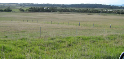
Location: Orbost River flats
Australian Soil Classification: Melanic, Eutrophic, Black DERMOSOL
Map Unit: River flats (rf)
Previous Site Name: EG9
General Landscape Description: Alluvial plain
Site Description: Level plain >1% slope
Land Use: Grazing
Native Vegetation: Riparian forest
Geology: Recent sediments
Soil Profile Morphology:
| Surface Soil | 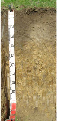 | ||
A11 | 0 – 25 cm | Very dark grey (10YR3/1); clay loam; strong medium polyhedral structure, weak consistence moist; pH 5.9 clear change to: | |
A12 | 25 – 55 cm | Black (10YR2/1); clay loam; moderate medium polyhedral structure; firm consistence moist; pH 6.3; changes to: | |
| A13 | 55 - 70 cm | Clay loam; pH 6.4; changes to: | |
Deep Subsoil | |||
D | 70 – 105 cm | Very dark grey (10YR3/1); clay loam; weak to very weak coarse prismatic structure; firm consistence moist; pH 6.7. |
Key Profile Features:
- Lack of texture contrast throughout the soil profile.
Soil Profile Characteristics:
- | pH | Salinity | ||
Surface Soil (A11 horizon) | Moderately Acid | Very Low | Non Sodic | None |
Subsoil (50-57 cm) | Slightly Acid | Very Low | Non Sodic | None1 |
Deeper Subsoil (70 -105 cm) | Slightly Acid | Very Low | Non Sodic | None2 |
Chemical and Physical Analysis:
Horizon | Horizon Depth (cm) | pH (water) | pH (CaCl2) | EC dS/m | Organic Carbon % | Total Nitrogen % | Exchangeable Aluminium ppm | Exchangeable Acididty meq/100g | Exchangeable Cations | Coarse Sand (0.2-2.0 mm) % | Fine Sand (0.02-0.2 mm) % | Silt (0.002-0.02 mm) % | Clay (<0.002 mm) % | Field Capacity % w/w | Wilting Point % w/w | |||
Ca | Mg | K | Na | |||||||||||||||
meq/100g | ||||||||||||||||||
A11 | 0-25 | 5.9 | 5.0 | 0.12 | 2.8 | 0.25 | <10 | 14 | 7.6 | 6.4 | 0.84 | 0.96 | 1 | 28 | 30 | 35 | 40.6 | 23.3 |
A12 | 25-55 | 6.3 | 5.3 | 0.07 | 2.5 | 0.19 | <10 | 14 | 10.0 | 7.1 | 0.22 | 0.63 | 1 | 27 | 33 | 29 | ||
A13 | 55-70 | 6.4 | 5.4 | 0.08 | 2.2 | 0.14 | <10 | 13 | 8.8 | 7.9 | 0.19 | 0.78 | 2 | 28 | 33 | 29 | ||
D | 70-105 | 6.7 | 5.5 | 0.07 | <10 | 9.5 | 6.9 | 8.3 | 0.15 | 0.84 | 1 | 34 | 31 | 29 | ||||
Management Considerations
Whole Profile
- There are no impeding layers in the profile which allows plant roots deep penetration.
Surface (A11) Horizon
- The relatively deep surface soil is moderately well structured and is friable when moist. Soil consistence when moist is also weak for this horizon. As a result of these attributes the surface soil will provide excellent seed germination conditions and few other limitations to root and water movement.
- The nutrient holding capacity of this soil is high (based on the sum of the exchangeable calcium, magnesium and potassium cations)
- Potassium levels are high and no response to potassium fertilizer would be expected. However below 25 cm the levels are quite low.
Subsoil Horizons
- The subsoil is non-sodic and reasonably well structured. Root and water movement will not be significantly restricted as a result.
Profile Described By: Ian Sargeant (2000)
Sampled Using: Auger
© State of Victoria (Agriculture Victoria) 1996 - .

This work, Victorian Resources Online, is licensed under a Creative Commons Attribution 4.0 licence. You are free to re-use the work under that licence, on the condition that you credit the State of Victoria (Agriculture Victoria) as author, indicate if changes were made and comply with the other licence terms.
The licence does not apply to ‘branding’ or some ‘images or photographs’ that may be owned by third parties. We ask you to seek prior approval to use images using the VRO feedback form. Access to higher quality images can also be provided on request.
This page was last updated on .