
EGW30
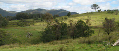
Location: W Tree
Australian Soil Classification: Haplic, Eutrophic, Black DERMOSOL
Map Unit: W Tree (Component 1)
Previous Site Name: EG30
General Landscape Description: Dissected plateau
Site Description: Upper hill-slope, W aspect 7% slope
Land Use: Grazing
Native Vegetation: Valley grassy forest
Geology: Tertiary basalt
Soil Profile Morphology:
| Surface soil |
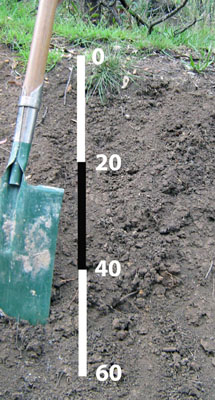 | ||
| A11 | 0 – 15 cm | Dark brown (10YR3/3); clay loam; moderate medium polyhedral structure; weak consistence moist; few sub-rounded basalt pebbles; pH 6.9; clear change to: | |
| A12 | 15 – 20 cm | Dark greyish brown (10YR4/2); clay loam; moderate medium polyhedral structure; weak consistence moist; few sub-rounded basalt pebbles ; clear change to: | |
| Subsoil | |||
B1 | 20 – 30 cm | Very dark greyish brown (10YR3/2); light clay; moderate medium prismatic structure parting to medium polyhedral; very firm consistence moderately moist; few (2 - 10%) sub-rounded basalt pebbles ; pH 6.1; gradual change to: | |
| B21 | 30 – 75 cm | Very dark greyish brown (2.5Y3/2); heavy clay; strong medium prismatic structure parting to medium polyhedral; very firm consistence moderately moist; few sub-rounded basalt pebbles; pH 6.6; gradual change to: | |
| B22 | 75 – 85+cm | Very dark greyish brown (2.5Y3/2); heavy clay; strong medium prismatic structure parting to medium polyhedral; very firm consistence moderately moist; many sub-rounded basalt fragments. |
Key Profile Features:
- Lack of strong texture contrast between the surface (A11 and A12) and subsoil (B1).
Soil Profile Characteristics:
- | pH | Salinity | ||
Surface soil (A11 horizon) | Slightly acid | Low | Non sodic | None |
Subsoil (B1 horizon) | Slightly acid | Low | Non sodic | None |
Chemical and Physical Analysis:
| Horizon | Horizon Depth (cm) | pH (water) | pH (CaCl2) | EC dS/m | Organic Carbon % | Total Nitrogen % | Free Fe2O3 % w/w | Exchangeable Acididty meq/100g | Exchangeable Cations | Coarse Sand (0.2-2.0 mm) % | Fine Sand (0.02-0.2 mm) % | Silt (0.002-0.02 mm) % | Clay (<0.002 mm) % | Field Capacity % w/w | Wilting Point % w/w | |||
Ca | Mg | K | Na | |||||||||||||||
meq/100g | ||||||||||||||||||
A11 | 0-15 | 6.9 | 6.3 | 0.12 | 2.3 | 0.18 | 11 | 25 | 15 | 0.9 | 0.2 | 14 | 31 | 16 | 24 | 41.1 | 24.1 | |
B1 | 20-30 | 6.1 | 5.2 | 0.11 | 3.15 | 15 | 12 | 10 | 0.33 | 0.47 | 4 | 19 | 36 | 34 | 45.8 | 24.0 | ||
B2 | 30-75 | 6.6 | 5.7 | 0.09 | 3.77 | 13 | 19 | 21 | 0.26 | 0.89 | 20 | 11 | 14 | 54 | 49.7 | 29.7 | ||
Management Considerations
Whole profile
- The profile is slightly acid throughout.
- These soils are very well drained due to their strongly developed subsoil structure.
- Plant available water capacity is considered to be moderate to high (estimated at 108 mm) based on the laboratory data and an effective rooting depth of 100 cm.
- The soil has a low organic matter content. Organic matter will be better maintained under rotational grazing, which enables stronger pasture recovery, rather than set stocking.
- The nutrient holding capacity of the soil is high (based on the sum of the exchangeable basic cations).
- Although the soils are fairly high in iron oxide, the pH is high enough to minimise phosphorus fixation.
- Potassium levels are high and no response to potassium fertilisers would be expected.
- The friable nature of the subsoil allows deep penetration of plant roots.
- The friable nature of the subsoil, together with the shallow depth to rock, can lead to problems with sealing of earth dams.
Profile Described By: David Rees and Grant Boyle, 2000.
© State of Victoria (Agriculture Victoria) 1996 - .

This work, Victorian Resources Online, is licensed under a Creative Commons Attribution 4.0 licence. You are free to re-use the work under that licence, on the condition that you credit the State of Victoria (Agriculture Victoria) as author, indicate if changes were made and comply with the other licence terms.
The licence does not apply to ‘branding’ or some ‘images or photographs’ that may be owned by third parties. We ask you to seek prior approval to use images using the VRO feedback form. Access to higher quality images can also be provided on request.
This page was last updated on .