
EGS260
Location: Bairnsdale East
Australian Soil Classification: Eutrophic, Subnatric, Grey SODOSOL
Map Unit: Stratford/riverine/Perry complex
Previous Site Name: EG260
General Landscape Description: Gently undulating plain.
Site Description: Almost level, within a broad drainage depression
Land Use: Grazing
Native Vegetation: Grassy woodland
Geology: Pleistocene alluvial sediments
Soil Profile Morphology:
Surface Soil
| A1 | 0 – 15 cm | Very dark to dark greyish brown; fine sandy loam to silty loam; clear change to: | 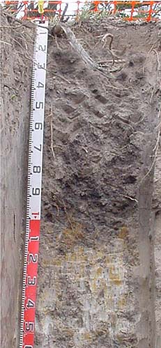 |
A2 | 15 – 20/30 cm | Light brownish grey; fine sandy loam; abrupt wavy change to: | |
Subsoil | |||
B21 | 15/20 – 110 cm | Dark greyish brown; medium clay; common (10 – 20%) cobbles (<200 mm); diffuse change to: | |
D | 110 – 150 cm | Light brownish grey and yellow brown mottles; medium clay. |
Key Profile Features:
- Strong texture contrast between the surface (A) and subsoil (B) horizons
- The colours of the upper part of the B horizon are much darker than normal for the Stratford map unit. This is most likely due to its low position in the landscape. It is likely the upper 110 cm of the profile represents a later alluvial deposit. Nevertheless the soil textures accord with those of the Stratford map unit.
Profile Described By: Ian Sargeant (2011).
© State of Victoria (Agriculture Victoria) 1996 - .

This work, Victorian Resources Online, is licensed under a Creative Commons Attribution 4.0 licence. You are free to re-use the work under that licence, on the condition that you credit the State of Victoria (Agriculture Victoria) as author, indicate if changes were made and comply with the other licence terms.
The licence does not apply to ‘branding’ or some ‘images or photographs’ that may be owned by third parties. We ask you to seek prior approval to use images using the VRO feedback form. Access to higher quality images can also be provided on request.
This page was last updated on .