
EGS257
Location: Glenaladale North
Australian Soil Classification: Bleached-Sodic, Magnesic, Brown CHROMOSOL
Previous Site Name: EG257
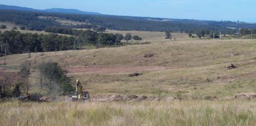
General Landscape Description: Rolling to steep low hills .
Site description: Upper slope, NNW aspect 5% slope
Land Use: Grazing
Native Vegetation: Shrubby dry forest
Geology: Late Devonian freshwater sediments
Soil Profile Morphology:
Surface Soil
| A1 | 0 – 10 cm | Very dark greyish brown (10YR3/2); fine sandy clay loam; moderate fine subangular blocky structure; few (2-10%) fine (<2 mm) round ferruginous concretions firm consistence dry; pH 5.2;clear change to: | 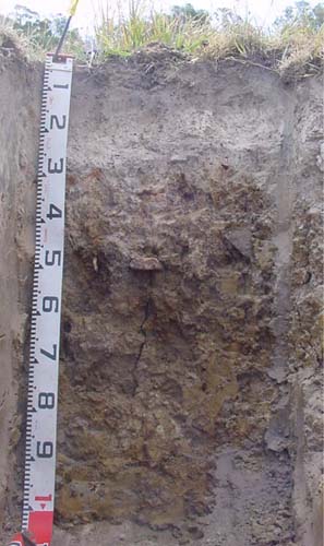 EG257 Profile |
| A2 | 10– 25 cm | Dark greyish brown (10YR4/2), conspicuously bleached, light brownish grey dry (10YR6/2d); fine sandy clay loam; massive; few fine round ferruginous concretions; pH 5.4; abrupt change to: | |
| Subsoil | |||
| B21 | 25 – 40 cm | Brown (7.5YR4/3) with common (10 -20%) fine yellowish brown (7.5YR5/6) mottles; medium clay; strong very coarse prismatic structure parting to fine angular blocky; very strong dry; few (2-10%) rounded tabular cobbles (<200 mm); pH 5.6; gradual change to: | |
| B22 | 40 – 70 cm | Brown (10YR4/3); medium heavy clay; strong coarse prismatic structure; few fine round organicsegregations; very strong dry; pH 5.9; diffuse change to: | |
| B23 | 70 – 120 cm | Dark yellowish brown (10YR4/4); heavy clay; moderate coarse polyhedral structure; few fine round organic segregations; very strong dry; pH 7.8; changing to: | |
| R | 120+ cm | Decomposing rock. |
Key Profile Features:
- Strong texture contrast between the surface (A) and subsoil (B) horizons.
- Strongly bleached subsurface horizon.
Soil Profile Characteristics:
pH | |||
Surface soil (A horizon) | Strongly Acid | Non-Sodic | - |
Subsoil (B21 horizon) | Moderately Acid | Non-Sodic | None |
Deep subsoil (B23 horizon) | Slightly Alkaline | Sodic | Moderate |
Chemical and Physical Analysis:
Horizon | Horizon Depth (cm) | pH (water) | pH CaCl2 | CE dS/m | Organic Carbon % | Total Nitrogen % | Exchangeable Aluminium | Exchangeable Acididty meq/100g | Exchangeable Cations | Coarse Sand (0.2-2.0 mm) % | Fine Sand (0.02-0.2 mm) % | Silt (0.002-0.02 mm) % | Clay (<0.002 mm) % | Field Capacity % w/w | Wilting Point % w/w | |||
Ca | Mg | K | Na | |||||||||||||||
meq/100g | ||||||||||||||||||
A1 | 0-10 | 5.2 | 4.4 | 0.07 | 7.4 | 3.9 | 96 | 14 | 1.5 | 0.8 | 0.1 | <0.1 | 5 | 61 | 17 | 8 | 24.9 | 6.4 |
A2 | 10-25 | 5.4 | 4.4 | <0.05 | 2.1 | 1.1 | 73 | 9.1 | 0.5 | 0.9 | <0.1 | 0.2 | 6 | 60 | 17 | 12 | 21.1 | 4.8 |
B21 | 25-40 | 5.6 | 4.4 | 0.11 | 200 | 16 | 0.5 | 6.5 | 0.1 | 1.2 | 2 | 28 | 13 | 56 | 34.7 | 19.1 | ||
B22 | 40-70 | 5.9 | 4.8 | 0.18 | 82 | 14 | 0.2 | 11 | 0.1 | 2 | 1 | 15 | 11 | 72 | 41.6 | 23.3 | ||
B23 | 70-120 | 7.8 | 6.8 | 0.17 | <5 | 4.4 | <0.1 | 10 | <0.1 | 1.8 | 1 | 22 | 22 | 55 | 35.6 | 19.1 | ||
Management Considerations
Whole profile
- Plant available water capacity is considered to be quite low (estimated at 37 mm) for this soil profile. This is based on an estimated effective rooting depth of 32 cm (i.e. surface soil and the top of the clay horizon). The dense and coarsely structured upper subsoil is likely to restrict rooting depth.
Surface (A) horizons
- The surface soil is strongly acid. This indicates aluminium toxicity could occur in crops sensitive to aluminium toxicity, eg lucerne. Test strips may be used to determine if lime is economically justified.
- The surface (A1) horizon has a very low nutrient holding capacity (based on the sum of the exchangeable calcium, magnesium, potassium and sodium cations). Organic matter is important for maintaining soil fertility, water holding capacity and enhancing surface soil structure; especially in soils such as these with high fine sand contents.
- Potassium is very low and a response to potassium fertiliser would be expected.
- The low wilting point values (i.e. 6.4 and 4.8) of the surface horizons indicate plants will be able to utilise very light rains when the soil is dry. However, due to the low water storage capacity, plants will soon suffer moisture stress unless further rainfall occurs.
- The presence of a conspicuously bleached subsurface (A2) horizon indicates periodic waterlogging occurs above the more slowly permeable subsoil. This horizon also has a very low inherent fertility and will become ‘spewy’ when wet.
- The dense and coarsely structured subsoil is sodic. This will result in significantly restricted root and water movement into the subsoil. The use of gypsum in association with deep ripping has been advocated by some researchers as an effective way to ameliorate sodic subsoils, but this may not be an economic option. Deep ripping should not be carried out when the subsoil is in a moist to wet condition.
- The deep subsoil slakes considerably and shows moderate dispersion when wet. Such soils are prone to tunnel and gully erosion, particularly where subsoil water accumulates, for example in gullies.
- The low exchangeable calcium to magnesium ratio (<0.1) in the subsoil indicates some nutrient imbalances (eg calcium deficiency) could occur.
Profile Described By: Ian Sargeant, 2001.
© State of Victoria (Agriculture Victoria) 1996 - .

This work, Victorian Resources Online, is licensed under a Creative Commons Attribution 4.0 licence. You are free to re-use the work under that licence, on the condition that you credit the State of Victoria (Agriculture Victoria) as author, indicate if changes were made and comply with the other licence terms.
The licence does not apply to ‘branding’ or some ‘images or photographs’ that may be owned by third parties. We ask you to seek prior approval to use images using the VRO feedback form. Access to higher quality images can also be provided on request.
This page was last updated on .