
EGS249
Location: Waygara
Australian Soil Classification: Bleached-Mottled, Magnesic, Yellow CHROMOSOL
Northcote Factual Key: Dy3.41
Great Soil Group: yellow podsolic
Mapping Unit: Waygara
AAP Mapping Unit: Silver Creek
Previous Site Name: EG249, CFTT04
General Landscape Description: Undulating plain.
Site description: 6% slope to south.
Land Use: Native forest
Native vegetation: Lowland forest.
Geology: Mid-Tertiary sediments regarded as colluvium.
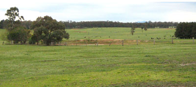
EG249 Landscape - typical of this unit 7 km south of the sample site.
Soil Profile Morphology:
Surface Soil
| A1 | 0 – 15 cm | Dark grey (10YR4/1); fine sandy clay loam; weak medium granular structure; weak consistence moist; clear smooth transition to: | 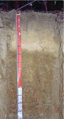 EG249 Profile |
| A2 | 15 – 52 cm | Very pale brown (10YR7/4) conspicuous bleach; fine sandy clay loam; massive; very weak consistence moist; clear smooth transition to: | |
| Subsoil | |||
| B1 | 52-60 cm | Brownish yellow (10YR6/6) with common medium faint yellowish brown (10YR5/4) mottles; sandy clay; massive; weak consistence moist; clear wavy transition to: | |
| B21 | 60-90 cm | Light yellowish brown (2.5Y6/4), many coarse distinct red (2.5YR4/6) mottles; light medium clay; moderate coarse polyhedral, parting to moderate medium polyhedral structure; very firm consistence moist; diffuse smooth transition to: | |
| B22 | 90-140 cm | Grey (10YR6/1) with many very coarse prominent dark yellowish brown (10YR4/6) mottles; light medium clay; moderate coarse prismatic, parting to strong fine polyhedral structure; very firm consistence moist. |
Key Profile Features:
- Lack of strong texture contrast between surface (A) horizons and subsoil (B21) horizon.
Horizon | Horizon Depth (cm) | pH (water) | pH (CaCl2) | EC dS/m | Exchangeable Cations | |||
Ca | Mg | K | Na | |||||
meq/100g | ||||||||
B21 | 60-90 | 5.9 | 5.1 | 0.05 | <0.05 | 7.9 | 0.07 | 0.65 |
B22 | 90-140 | 5.7 | 4.8 | 0.07 | <0.05 | 8.6 | 0.08 | 0.91 |
Horizon | Horizon Depth (cm) | Exchangeable Aluminium mg/kg | Exchangeable Acidity meq/100g | Field Capacity pF 2.5 | Wilting Point pF 4.2 | Coarse Sand (0.2-2.0 mm) | Fine Sand (0.02-0.2 mm) | Silt (0.002-0.02 mm) | Clay (<0.002 mm) |
B21 | 60-90 | <10 | 8.6 | 32.4 | 19.1 | 20.7 | 16.3 | 11.5 | 50 |
B22 | 90-140 | 32 | 9.9 | 30.6 | 22.3 | 15.2 | 14.4 | 11 | 57 |
Management Considerations
- The calcium and potassium levels in the subsoil are extremely low, but the levels nearer the surface are not known.
- The subsoil has low calcium as well as a low calcium to magnesium ratio. Calcium deficiencies may occur as a result.
NOTE: This profile is paler than is typical for Silver Cree loam mapping unit. It better fits into Boolarra loam in terms of colour but Silver Creek as far as texture is concerned.
Profile Described by: Ian Sargeant and Justin Wong (June 1999).
© State of Victoria (Agriculture Victoria) 1996 - .

This work, Victorian Resources Online, is licensed under a Creative Commons Attribution 4.0 licence. You are free to re-use the work under that licence, on the condition that you credit the State of Victoria (Agriculture Victoria) as author, indicate if changes were made and comply with the other licence terms.
The licence does not apply to ‘branding’ or some ‘images or photographs’ that may be owned by third parties. We ask you to seek prior approval to use images using the VRO feedback form. Access to higher quality images can also be provided on request.
This page was last updated on .