
EGS245
Location: Marlo
Australian Soil Classification: Melacic Humic/Humosequic, Semiaquic PODOSOL
Map Unit: Croajingalong (Component 1)
Previous Site Name: EG245
General Landscape Description: Undulating rises
Site description: Level
Land Use: Residential subdivision (undeveloped)
Native Vegetation: Banksia Woodland and Wet Heathland
Geology: Recent aeolian sediments
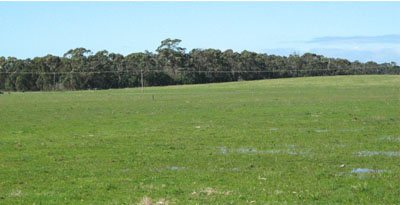
Undulating plains and low dunes typical of the Marlo map unit. Photo taken on the Marlo
Plains Road about 8 km east of the sampled site.
Soil Profile Morphology:
| Surface soil | |||
A1 | 0 – 50 cm | Black (10YR2/1); loamy sand; clear change to: | |
A2 | 50 – 60 cm | Greyish brown (10YR5/2); loamy sand; abrupt change to: | |
Subsoil | |||
Bhs | 60 -65 cm | Dark brown (10YR3/3); cemented sand; clear change to | |
B2 | 65 – 80 cm | Yellowish brown mottled with light yellowish brown; clayey sand. | |
Chemical and Physical Analysis:
Horizon | Horizon Depth (cm) | pH (water) | pH (CaCl2) | EC dS/m | Exchangeable Acididty meq/100g | Exchangeable Cations | |||
Ca | Mg | K | Na | ||||||
meq/100g | |||||||||
A1 | 0-20 | 4.9 | 3.6 | <0.05 | 1.3 | 0.33 | 0.28 | 0.03 | 0.28 |
B2 | 65-80 | 5.8 | 4.7 | 0.08 | 0.99 | 0.48 | 0.58 | 0.05 | 0.58 |
Management considerations
- The surface soil is strongly acid and a response to lime would be expected.
- The surface soil has a very low inherent fertility (based on the sum of the exchangeable basic cations). Such strongly leached soils are also likely to be naturally deficient in nitrogen, phosphorus, sulphur and potassium
Profile Described By: Ian Sargeant, 2011.
© State of Victoria (Agriculture Victoria) 1996 - .

This work, Victorian Resources Online, is licensed under a Creative Commons Attribution 4.0 licence. You are free to re-use the work under that licence, on the condition that you credit the State of Victoria (Agriculture Victoria) as author, indicate if changes were made and comply with the other licence terms.
The licence does not apply to ‘branding’ or some ‘images or photographs’ that may be owned by third parties. We ask you to seek prior approval to use images using the VRO feedback form. Access to higher quality images can also be provided on request.
This page was last updated on .