
EGC220
Location: Lake Tyers
Australian Soil Classification: Melacic, Humosesquic, Aeric PODOSOL
Map Unit: Stockdale with Munro
Previous Site Name: EG220
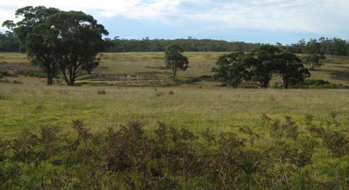
General Landscape Description: Rolling low hills.
Site description: Simple mid slope 3% north east.
Native Vegetation: Lowland forest.
Geology: Tertiary sediments.
 |
Soil Profile Morphology:
Surface Soil
| A1 | 0 – 25 cm | Very dark grey (10YR3/1); sand; apedal, single grain structure; diffuse change to: | 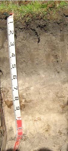 |
| A2 | 25 – 60 cm | Dark grey (10YR4/1); sand; apedal, single grain structure; clear change to: | |
| A3 | 60 – 75 cm | Greyish brown (10YR5/2); sand; apedal, single grain structure; diffuse change to: | |
| Subsoil | |||
| Bhs | 75 – 95 cm | Greyish brown (10YR5/2); sand; apedal, single grain structure; with pockets of a mainly very dark brown (10YR3/2) weakly cemented organic pan; clear change to: | |
| C | 60 – 90 mm | Light brownish grey (10YR6/2); sand; apedal, single grain structure |
Key Profile Features:
- Deep sandy surface.
- Accumulation of iron-organic matter compounds (coffee rock) in the subsoil.
Soil Profile Characteristics:
| - | pH | Salinity | |
Surface soil (A1 horizon) | Strongly acid | Very low | Non-sodic |
Subsurface (A2horizon) | Strongly acid | Very low | Non-sodic |
Deeper subsoil (70-95 cm) | Moderately acid | Very low | Non-sodic |
Chemical and Physical Analysis:
Horizon | Horizon Depth (cm) | pH (water) | pH (CaCl2) | EC dS/m | Exchangeable Aluminium ppm | Exchangeable Acidity meq/100g | Exchangeable Cations | |||
Ca | Mg | K | Na | |||||||
meq/100g | ||||||||||
A1 | 0-25 | 5.3 | 4.2 | <0.05 | <10 | 7.1 | 2.2 | 0.77 | 0.18 | 0.1 |
A2 | 25-60 | 5.5 | 4.3 | <0.05 | 20 | 4.0 | 0.76 | 0.22 | <0.05 | 0.057 |
A3 | 60-75 | 5.9 | 4.8 | <0.05 | <10 | 1.4 | 0.55 | 0.38 | <0.05 | 0.077 |
Bhs | 75-95 | 6.0 | 5.0 | <0.05 | <10 | 4.9 | 1.1 | 1.4 | <0.05 | 0.18 |
Horizon | Horizon Depth (cm) | Oxidisable Organic Carbon % | Total Nitrogen % | Field Capacity pF2.5 | Wilting Point pF4.2 | Coarse Sand (0.2-2.0 mm) % | Fine Sand (0.02-0.2 mm) % | Silt (0.002-0.02 mm) % | Clay (<0.002 mm) % |
A1 | 0-25 | 1.8 | 0.085 | 10.6 | 5.4 | 69 | 20 | 1 | 2 |
A2 | 25-60 | 0.66 | <0.05 | 8.4 | 1.5 | 68 | 24 | 1 | 2 |
A3 | 60-75 | <0.30 | <0.05 | 6.7 | 1.2 | 64 | 27 | 1 | 3 |
Bhs | 75-95 | 0.5 | <0.05 | 9.2 | 2.4 | 58 | 30 | 4 | 4 |
Management Considerations
- If the soil was under pasture with an effective rooting depth of 70 cm the plant available water capacity is considered to be low estimated at 52 mm. Because of the low wilting points throughout the profile, plants will be able to use very light rains when the soil is dry. Due to the low water storage capacity of the soil, plants will suffer water stress unless further rains occur.
- These strongly acid sandy soils have a low nutrient holding capacity and are considered to be infertile. They are naturally deficient in nitrogen, phosphorus, sulphur and potassium. Nitrate and sulphate are readily removed by leaching. Deficiencies of trace elements such as copper, zinc and molybdenum are likely to occur. The trace element boron (B) leaches rapidly through acid sandy soils and deficiencies are also likely to occur.
Profile Described By: Heather Adams, Julieanne Sargant and Ian Sargeant, June 2009.
© State of Victoria (Agriculture Victoria) 1996 - .

This work, Victorian Resources Online, is licensed under a Creative Commons Attribution 4.0 licence. You are free to re-use the work under that licence, on the condition that you credit the State of Victoria (Agriculture Victoria) as author, indicate if changes were made and comply with the other licence terms.
The licence does not apply to ‘branding’ or some ‘images or photographs’ that may be owned by third parties. We ask you to seek prior approval to use images using the VRO feedback form. Access to higher quality images can also be provided on request.
This page was last updated on .