
EGC208
Location: Dargo
Australian Soil Classification: Bleached, Eutrophic, Brown CHROMOSOL
Map Unit: Dargo (Component 1)
Previous Site Name: EG208
General Landscape Description: Rolling low hills
Site description: Simple mid slope - 8% facing north
Land Use: Grazing
Native Vegetation: Grassy woodland
Geology: Silurian granite (metamorphosed Ordovician sediments upslope)
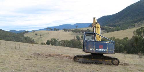
Rolling low hills of the Dargo map unit. The steep to very steep hills on the right are comprised of metamorphosed
Ordovician sediments and mapped as the Talbotville map unit. The excavator is back- filling the soil pit.
Soil Profile Morphology:
Surface Soil
| A1 | 0 – 10 cm | Dark brown (7.5YR3/2); sandy loam; moderate fine (2 – 5 mm) granular structure; weak consistence, moist; few (2 - 10 %) coarse angular pebbles (20 – 60 mm) derived from metamorphosed sediments upslope; pH 5.1; clear change to: | 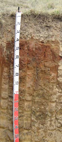 EG208 profile |
| A2 | 10 – 35 cm | Brown (7.5YR5/4), conspicuously bleached (7.5YR7/1d); sandy loam; apedal; weak consistence dry; abundant (50 – 90%) angular cobbles (60 -200 mm) derived from metamorphosed sediments upslope; pH 6.0; sharp change to: | |
| Subsoil | |||
| B21 | 36 – 70 cm | Dark red (2.5YR3/6); medium heavy clay; strong coarse polyhedral structure; strong consistence dry; pH 7.4; gradual change to: | |
| B22 | 70 – 120 cm | Dark yellowish brown (10YR5/4) mottled with yellowish red; medium clay; strong coarse polyhedral structure; strong consistence dry; pH 8.2; diffuse change to: | |
| B23 | 120 – 180 cm | Dark yellowish brown (10YR5/4) mottled with yellowish red; medium clay, slightly sandy; moderate coarse lenticular structure; strong consistence dry. | |
Key Profile Features:
- Sharp texture contrast between the surface soil (A horizons) and the subsoil (B horizons)
- Stone layer just above the clay subsoil.
Soil Profile Characteristics:
- | pH | ||
Surface soil (A horizon) | Strongly acid | Non-sodic | Nil |
Subsurface soil (A2 horizon) | Moderately acid | Non-sodic | Slight |
Subsoil (B21 horizon) | Slightly alkaline | Non-sodic | Nil |
Chemical and Physical Analysis:
Horizon | Horizon Depth (cm) | pH (water) | pH (CaCl2) | EC dS/m | Organic Carbon % | Exchangeable Aluminium ppm | Exchangeable Acididty meq/100g | Exchangeable Cations | Coarse Sand (0.2-2.0 mm) % | Fine Sand (0.02-0.2 mm) % | Silt (0.002-0.02 mm) % | Clay (<0.002 mm) % | Field Capacity % w/w | Wilting Point % w/w | |||
Ca | Mg | K | Na | ||||||||||||||
meq/100g | |||||||||||||||||
A1 | 0-10 | 5.1 | 4.4 | 0.06 | 4.4 | 25 | 11 | 2.8 | 0.82 | 0.3 | 0.07 | 20 | 53 | 11 | 10 | 21.9 | 8.6 |
A2 | 10-35 | 6.0 | 5.1 | <0.05 | 1.0 | <10 | 2.6 | 2.6 | 0.63 | 0.12 | 0.06 | 18 | 58 | 14 | 8 | 18.0 | 3.4 |
B21 | 35-70 | 7.4 | 6.4 | 0.07 | 0.56 | 9 | 13 | 0.3 | 0.74 | 5 | 21 | 12 | 59 | 40.6 | 23.6 | ||
B22 | 70-120 | 8.2 | 7.2 | 0.08 | <0.30 | 9.6 | 15 | 0.25 | 1.2 | 11 | 34 | 16 | 35 | 34.1 | 17.6 | ||
Management considerations
Whole profile
- Plant available water content for this profile is considered to be very low, estimated at 25 mm, as the effective rooting depth, considered here to be 40 cm, is largely limited by the dense and coarsely structured nature of the subsoil.
- The low wilting points (8.6 and 3.4 %) of the surface soils indicates the plants are able to utilize very light rains when the soil is dry. However, due to the low water storage capacity, plants will soon suffer moisture stress unless further rains occur.
- The surface soil is strongly acid. However the level of exchangeable aluminium is reasonably low (25 mg/kg) and is unlikely to affect the growth of aluminium sensitive species, except the most sensitive. Lime can be used to increase soil pH but a pH/aluminium test is best preformed by taking samples across the paddock and bulked together. The use of test strips to observe lime response should be used as an aid in evaluating its cost/benefit. For this soil a response to lime (about 1-2 tonnes/ha) would be expected.
- The organic matter content of the surface soil is high. Such levels result in a good surface structure and stability.
- Potassium is at a low level for pastures and a response to potassium fertilisers would be expected.
- The nutrient holding capacity of the surface (A1 and A2) horizons is very low (based on the sum of the exchangeable calcium, magnesium, potassium and sodium cations).
- Root and water movement is likely to be restricted in the dense and coarsely structured subsoil although the red colour of the subsoil indicates the soil is generally well drained.
- The roots tend to follow cracks between the soil aggregates and can only extract part of the soil water.
- The subsoil and the deep subsoil are slightly dispersive but slake considerably. If the subsoil is exposed, for example by a gully head, headward erosion is highly likely.
Profile Described By: Ian Sargeant, Heather Adams and Julieanne Sargant, June 2009.
© State of Victoria (Agriculture Victoria) 1996 - .

This work, Victorian Resources Online, is licensed under a Creative Commons Attribution 4.0 licence. You are free to re-use the work under that licence, on the condition that you credit the State of Victoria (Agriculture Victoria) as author, indicate if changes were made and comply with the other licence terms.
The licence does not apply to ‘branding’ or some ‘images or photographs’ that may be owned by third parties. We ask you to seek prior approval to use images using the VRO feedback form. Access to higher quality images can also be provided on request.
This page was last updated on .