
EGC201
Location: Swifts Creek
Australian Soil Classification: Melanic, Eutrophic, Brown DERMOSOL
Map Unit: Walnut (Component 1)
Previous Site Name: EG201
General Landscape Description: Valley flat
Site description: Level
Land Use: Grazing on annual pasture
Native Vegetation: Dry valley forest
Geology: Recent alluvium
Soil Profile Morphology:
| Surface soil | 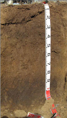 | ||
| A11 | 0 – 20 cm | Dark brown (10YR3/3); silty clay loam; strong fine (2 – 5 mm) granular structure; firm consistence dry; clear change to: | |
| A12 | 20 – 45 cm | Very dark greyish brown (10YR3/2); silty clay loam; strong fine (2 – 5 mm) granular structure; firm consistence dry; diffuse change to: | |
| A13 | 45 – 85 cm | Dark brown (10YR4/3); fine sandy clay loam; weak fine (2 – 5 mm) granular structure; firm consistence dry; clear change to: | |
| Deep subsoil (buried soil) | |||
| D | 85 – 105+ cm | Very dark grey (10YR3/1); clay loam; moderate medium (5 – 10 mm) polyhedral structure; firm dry | |
Key Profile Features:
- Little colour or texture changes down the soil profile.
- Well structured upper profile
Soil Profile Characteristics:
- | pH | Salinity | ||
Surface (A1 horizon) | Strongly Acid | Very Low | Non-sodic | None |
Subsoil (A12 horizon) | Slightly Acid | Very Low | Non-sodic | None |
Deeper subsoil (D horizon) | Slightly Alkaline | Very Low | Non-sodic | None |
Chemical and Physical Analysis:
Horizon | Horizon Depth (cm) | pH (water) | pH (CaCl2) | EC dS/m | Organic Carbon % | Total Nitrogen % | Exchangeable Aluminium ppm | Exchangeable Acididty meq/100g | Exchangeable Cations | Coarse Sand (0.2-2.0 mm) % | Fine Sand (0.02-0.2 mm) % | Silt (0.002-0.02 mm) % | Clay (<0.002 mm) % | Field Capacity % w/w | Wilting Point % w/w | |||
Ca | Mg | K | Na | |||||||||||||||
meq/100g | ||||||||||||||||||
A11 | 0-20 | 5.5 | 4.9 | 0.12 | 3.3 | 0.26 | <10 | 8.3 | 7.6 | 1.6 | 0.99 | 0.084 | 5 | 42 | 26 | 19 | 35.4 | 10.9 |
A12 | 20-45 | 6.5 | 5.7 | 0.05 | 2.1 | 0.12 | 4.4 | 9.3 | 1.9 | 0.29 | 0.14 | 12 | 38 | 25 | 19 | 33.3 | 10.3 | |
A13 | 45-85 | 7.2 | 6.4 | <0.05 | 0.95 | 9.2 | 2.7 | 0.18 | 0.22 | 8 | 46 | 24 | 18 | 30.4 | 9.1 | |||
D | 85-105 | 7.5 | 5.8 | 0.05 | 1.8 | 14 | 5.3 | 0.25 | 0.37 | 3 | 26 | 37 | 27 | 40.1 | 15.6 | |||
Management Considerations
Whole profile
- Plant available water capacity is considered to be low. This is based on an estimated effective rooting depth of 85 cm (i.e. the surface soil and the upper subsurface soil).
- The relatively deep surface soil is well structured.
- Infiltration of water into the well structured surface soil will be quite high. This horizon is also very well drained.
- The nutrient holding capacity of the surface (A1) horizon is moderate (based on the sum of the exchangeable cations). The organic matter for this soil is high which adds in both water and nutrient holding capacity.
- The upper subsurface soil is also well structured
Profile Described By: Heather Adams, Julieanne Sargant and Ian Sargeant, June 2009.
© State of Victoria (Agriculture Victoria) 1996 - .

This work, Victorian Resources Online, is licensed under a Creative Commons Attribution 4.0 licence. You are free to re-use the work under that licence, on the condition that you credit the State of Victoria (Agriculture Victoria) as author, indicate if changes were made and comply with the other licence terms.
The licence does not apply to ‘branding’ or some ‘images or photographs’ that may be owned by third parties. We ask you to seek prior approval to use images using the VRO feedback form. Access to higher quality images can also be provided on request.
This page was last updated on .