
Flood Data Mapping
In late 2000, (the former) DNRE completed its Flood Data Transfer Project, which was developed to produce high quality, consistent and comprehensive Geographic Information System (GIS) maps showing a range of flood data for urban and rural flood plains in the East Gippsland Shire. The mapping and assessment has only been carried out for locations where information is available and of sufficient quality to justify delineation. Hence, the mapping is not a comprehensive range of all flood plains or all flooding problem areas, and broad flood areas indicated on the map may have some pockets of flood-free land (EGIS, 2000 June). Nonetheless, the Flood Data Transfer Project contains the most up-to-date flood information available. A key outputs of the Flood Data Transfer project is the formulation of Flood Data Maps that detail Floodway data and 1% Annual Exceedance Probability (AEP) Flood Extents.
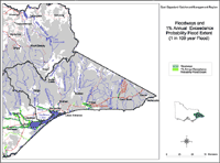 Floodways and 1% Annual Exceedance Probability Flood | This map shows Floodways and areas of 1% Annual Exceedance Probability (AEP) Flood Extent. This data was sourced from the Flood Data Transfer Project, developed by EGIS Consulting. |
Floodways
Floodways generally comprise the most hazardous parts of the floodplain and are often associated with fast flowing floodwater and/or areas of relatively deep flooding (SKM, 1999). Parts of the Cann River, the lower Snowy River, the Tambo River and the Mitchell River have been identified as floodway areas. Areas bordering the Gippsland Lakes have also been identified. The Mitchell River Floodway Area extends from Glendale along the lower reaches of the river as far as Bairnsdale. The Tambo River floodway occurs along the section of the river to the south of Bruthen. A floodway is also located along the lower reaches of the Nicholson River, which lies between the Mitchell and the Tambo Rivers. Floodways have also been identified where these rivers enter the Gippsland Lakes. The Snowy River floodways cover a substantial area to the northwest of Orbost and south as far as Marlo - extending considerable distances east and west of the main river channel. The middle section of Cann River has also been identified as a floodway, together with a small area around Bemm River.
1% Annual Exceedance Probability Flood Extent
The 1% Annual Exceedance Probability (AEP) flood event is one in which the applicable flood flow has a probability of 1% (or 1 in 100) of being equalled or exceeded. The flood data maps provide a record of all past mapping and known problem areas and should only be used for identifying the location of past flood problem areas (EGIS Consulting, 2000). This data is based on hydrological modelling and mapping, and will be used in the revision and development of Shire Planning Scheme overlays. The flood extent data, shown as green on the map, has similar extents to the floodways in East Gippsland. The 1% Annual Exceedance Probability (AEP) flood extents continue further west from Orbost than the delineated floodway.
Planning
The Annual Exceedance Probability (AEP) Flood extent will form the basis for subsequent declaration of the Land Subject to Inundation Overlays (LSIO) and planning controls under the Victorian Planning Provision (VPP). LSIO identify flood prone land where the flood risk is not considered sufficient to denote a floodway or where there is insufficient information to define the floodway. Similarly, the floodway extents should be used for determining Urban Floodway Zones and Rural Floodway Overlays under the VPP. The criteria to delineate floodways and flood extents is in accordance with the Advisory Notes for Guidelines for Delineating Floodways (DNRE, July 1998), which incorporate flooding characteristics, socioeconomic and environmental factors.
The total area of 1% AEP flooding mapped is approximately 300 km2. This mapping has been extended for the purpose of the RFMS to approximately show other floodplains using the mapping of alluvial soils from geological mapping of the area and anecdotal information. This data mapping has been compared with the LSIO included in the Shire of East Gippsland’s Planning Scheme and it was found that areas in the DSE mapping not included in the Shires LSIO are the Nicholson River, Tambo River, Swifts Creek Town, Cabbage Tree Creek, Buchan Town, Bemm River Town, Cann River, Genoa Town, and other Lakes and Inlets.
For the East Gippsland Shire there is a need to review the current LSIO in light of the RFMS. While all Shires recognise flooding to some degree as a planning issue in their MSS and Local Policies, it is desirable for some measure of consistency to be achieved across municipal boundaries, particularly for those Shires sharing the floodplains of particular rivers and streams.
References:
EGIS Consulting (2000). Flood Data Transfer Project (the former) DNRE. Victoria.
SKM (1999). Sinclair Knight Merz. West Gippsland Catchment Management Authority: Regional Floodplain Strategy. Melbourne, Victoria.
© State of Victoria (Agriculture Victoria) 1996 - .

This work, Victorian Resources Online, is licensed under a Creative Commons Attribution 4.0 licence. You are free to re-use the work under that licence, on the condition that you credit the State of Victoria (Agriculture Victoria) as author, indicate if changes were made and comply with the other licence terms.
The licence does not apply to ‘branding’ or some ‘images or photographs’ that may be owned by third parties. We ask you to seek prior approval to use images using the VRO feedback form. Access to higher quality images can also be provided on request.
This page was last updated on .