
GL44 (8321) North-Western Shore of Lake Wellington
|
This information has been developed from the publications:
|
| Location: | 218865 (8321). One kilometre south of jetty. | 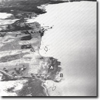 Marlay Point. Sandy 'levee' deposits (A) Phragmites (B) Eroding shoreline of floodplain and levee deposits (arrowed) |
Abstract: | Eroding shoreline; sandy ridge (possibly from river levee). | |
Access: | Clydebank jetty road. | |
Ownership: | Private land. | |
Geomorphology: | West of Lake Wellington is an extensive alluvial plain with remnants of former river channels and low sinuous sandy ridges that extend north of Marlay Point to the shoreline of the lake. The ridges are possibly former levee banks capped by Aeolian sands and road cuttings along the Clydebank jetty road display sections in this material. | |
Erosion is predominant south of the jetty although the rate of shoreline retreat is uneven. The most rapidly eroding sectors are in the fine grained sediments of the alluvial plain - the sinuous sandy ridges project as small promontories into the lake. Phragmites persists only on one small sector of the shore where grazing has been excluded. | ||
Significance: | Regional. This is an exposed shoreline which displays the erosive effect of waves generated across a long easterly fetch. The small area of Phragmites illustrates the role of grazing pressure on reed swamp die-back. | |
Management: | Continued exclusion of grazing from the Phragmites area would allow further assessment to be made of the impact of grazing. | |
Sites GL43-46
© State of Victoria (Agriculture Victoria) 1996 - .

This work, Victorian Resources Online, is licensed under a Creative Commons Attribution 4.0 licence. You are free to re-use the work under that licence, on the condition that you credit the State of Victoria (Agriculture Victoria) as author, indicate if changes were made and comply with the other licence terms.
The licence does not apply to ‘branding’ or some ‘images or photographs’ that may be owned by third parties. We ask you to seek prior approval to use images using the VRO feedback form. Access to higher quality images can also be provided on request.
This page was last updated on .