
GL42 (8321) Swell Point
|
This information has been developed from the publications:
|
| Location: | 275880 (8321). Northern shore of Lake Wellington, three kilometres south-east of Strathfieldsaye. | 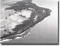 Swell Point. Older barrier and sand plain (A) Sand and gravel ridges (B) |
Abstract: | Gravel and sand beach ridges and enclosed swamps. | |
Access: | Boat in Lake Wellington. | |
Ownership: | Private land. | |
Geomorphology: | The northern shore of Lake Wellington from Swell Point to Roseneath Point is backed by two distinct types of terrain. The marginal bluff lies approximately 1,500 metres from the lake shore - in front of the bluff is a low sand plain with minor and irregular ridges and depressions. The relief and leached soil profiles indicate this to be an early barrier formation, probably the prior barrier. This sand plain extends to the lake shore in the embayment south-east of Strathfieldsaye where low lake shore cliffs provide sections in the sand material. | |
In front of the sand plain and extending to the Lake Wellington shore between Swell Point and Roseneath Point, is a younger beach ridge plain of distinct, parallel ridges, composed of gravely sand. The sediment was derived from the Avon River to the west and from erosion of the marginal bluff at Strathfieldsaye and the ridges were rapidly built by wave action on the lake shores during the mid-Holocene when the sea flooded the Lake Wellington depression. | ||
With the recent die-back of fringing reedswamp, the outermost ridge is generally eroding although small temporary ridges and cheniers are built during periods of high lake level. | ||
Significance: | Regional. The younger gravely ridges illustrate the importance of a local sediment source in building gravely beach ridges. This contrasts with the absence of ridges of this type on the southern shore of Lake Wellington. | |
Management: | Quarrying of gravel from the younger ridges would reduce the significance of the site. Because of the coarse texture of the sediments, they are not likely to be subject to wind erosion if vegetation was removed. Foreshore development, including marina construction, should be prohibited as this would seriously diminish the value of the site. | |
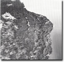 Detail of ridges - Swell Point |
© State of Victoria (Agriculture Victoria) 1996 - .

This work, Victorian Resources Online, is licensed under a Creative Commons Attribution 4.0 licence. You are free to re-use the work under that licence, on the condition that you credit the State of Victoria (Agriculture Victoria) as author, indicate if changes were made and comply with the other licence terms.
The licence does not apply to ‘branding’ or some ‘images or photographs’ that may be owned by third parties. We ask you to seek prior approval to use images using the VRO feedback form. Access to higher quality images can also be provided on request.
This page was last updated on .