
GL4 (8522) Cuspate Forelands at Lakes Entrance
|
This information has been developed from the publications:
|
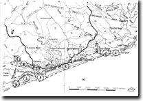
| Location: | 855058 (8422). Lakes Entrance. | 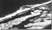 Barrier and the artificial entrance to the Gippsland Lakes - Lakes Entrance |
Abstract: | Sandy cuspate forelands, loped sand bar. | |
Access: | Footbridge at Lakes Entrance; boat to Hopetoun Channel. | |
Ownership: | Crown land. | |
Geomorphology: | The artificial entrance cut through the outer barrier has been protected by a series of wooden jetties, granite walls and concrete piers that extend over 100 metres seaward of high water mark. Substantial shoreline re-alignment has taken place adjacent to both eastern and western piers, and two prominent sandy forelands surmounted by foredune ridges and transgressive dunes now project up to 150 metres beyond the 1879 shoreline. The accretion of these forelands is a consequence of the interruption to longshore drift by the protruding jetties and the relatively even growth of forelands on both eastern and western sides suggests and approximate balance in the quantity of sand arriving from either direction. | |
The looped sand bar that surrounds the entrance is essentially an ebb-tidal delta, built where the ebb current directed out of the entrance diminishes to allow substantial deposition. The symmetrical form of this lobe of sand as indicated by the pattern of breaking waves is further evidence of the balance of longshore drift. | ||
Significance: | State. The prograding sectors are in marked contrast with the erosion of foredunes of sandy barrier elsewhere in Victoria. They illustrate the impact of artificial structures on coastal dunes and landform. | |
Management: | Of critical importance is the need to devise either a safer navigational system over the bar of the ebb-tidal delta or to find an engineering solution to the problem of dispersing the sediment deposited here. | |
References: | Fryer (1973) Bird, E.C.F. (1978). The Geomorphology of the Gippsland Lakes Region. Publication No. 186, Environmental Studies Series, Ministry for Conservation, Victoria. | |
 Hidden Lake (A), Hopetoun Channel (B), Outer Barrier (C), Inner Barrier (D), Cuspate foreland at Lakes Entrance (E), Blowouts (arrowed). |
© State of Victoria (Agriculture Victoria) 1996 - .

This work, Victorian Resources Online, is licensed under a Creative Commons Attribution 4.0 licence. You are free to re-use the work under that licence, on the condition that you credit the State of Victoria (Agriculture Victoria) as author, indicate if changes were made and comply with the other licence terms.
The licence does not apply to ‘branding’ or some ‘images or photographs’ that may be owned by third parties. We ask you to seek prior approval to use images using the VRO feedback form. Access to higher quality images can also be provided on request.
This page was last updated on .