
GL36 (8422) Tannin Point
|
This information has been developed from the publications:
|
| Location: | 560976 (8422). 700 metres north of Wattle Point. | 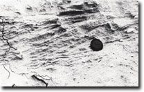 Tannin Point. Cross-bedded coarse sands, grits and minor gravels. |
Abstract: | Fluvial and barrier sands and gravels. | |
Access: | Walk around Lake Victoria shore from Wattle Point. | |
Ownership: | Private land. | |
Geomorphology:: | Eroding of cliff sections on the Lake Victoria shoreline show stratified and cross bedded deposits of sand and gravel up to 3 metres thick overlain by leached dune sands. The structure and composition of the materials appears similar to those exposed near Point Tuner on the eastern edge of Banksia Peninsula and is indicative of fluvial origin although in part it may also represent beach deposits of the prior barrier. The cliffs are the outer edge of a distinct coastal terrace approximately 4 metres above lake level and several hundred metres wide which lies in front of the marginal bluff between Wattle Point and Mason Bay. Because the marginal bluff has been isolated here from the effects of the Holocene sea level rise, it is much more subdued in form than its counterpart on the east of Lake Victoria and Lake King, e.g. Tambo Bluff. | |
Significance: | Regional. The status of the terrace requires further investigation for its origin and stratigraphical relationship is not known. | |
Management: | Cliff sections are being degraded by stock trampling resulting in extensive sand slumping on the upper sandy parts of the section which obscures the details of bedding lower in the cliff. Exclusion of stock from part of the cliffed exposure is necessary to maintain the value of the site. | |
References: | Bird, E.C.F. (1978). The Geomorphology of the Gippsland Lakes Region. Publication No. 186, Environmental Studies Series, Ministry for Conservation, Victoria. | |
 Sites GL 36-38 |
© State of Victoria (Agriculture Victoria) 1996 - .

This work, Victorian Resources Online, is licensed under a Creative Commons Attribution 4.0 licence. You are free to re-use the work under that licence, on the condition that you credit the State of Victoria (Agriculture Victoria) as author, indicate if changes were made and comply with the other licence terms.
The licence does not apply to ‘branding’ or some ‘images or photographs’ that may be owned by third parties. We ask you to seek prior approval to use images using the VRO feedback form. Access to higher quality images can also be provided on request.
This page was last updated on .