
GL 34 (8321) Barrier Dunes - Ninety Mile Beach
|
This information has been developed from the publications:
|
| Location: | 280643 (8321). 9 kilometres south-west of Golden Beach. | 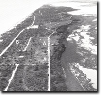 East of Seaspray. Older dune ridge (A). Parallel ridges of outer barrier (B). |
Abstract: | Parallel ridges of outer barrier, irregular dunes of earlier barrier formation. | |
Access: | Seaspray - Golden Beach Road. | |
Ownership: | Private land | |
Geomorphology: | The number of parallel ridges that comprise the outer barrier diminishes progressively from a maximum of 13 near Golden Beach to a single high foredune at Seaspray. This changing configuration of the barrier can be readily appreciated by making transects across the ridges at intervals along the 25 kilometres of roadway between Seaspray and Golden Beach. Behind the distinct outer barrier ridges is a zone of sandy terrain of variable width that extends to the salt marsh on the shore of Lake Reeve. In places this is a featureless sand plain which may represent sites of former tidal inlets to Lake Reeve before emplacement of the outer barrier but there are also areas of irregular dune relief consisting of low hummocks and hollows with no discernible orientation. These dunes have deeply leached soil profiles and the vegetation, which includes Banksia serrata, a species that is typical of acidic inner barrier sandy soils, indicates their possible Pleistocene rather than Holocene origin. Although of different configuration, they may be of similar age and origin to the ridges on Rotomah Island referred to as Site GL-30. | |
Significance: | State. The exact nature and age relationships of the hummocky older dunes has not been determined - hence this is an important site in displaying the evolution of the Gippsland Lakes barriers. | |
Management: | Most of the area occupied by the older dunes has been subdivided but is not built on. An area approximating to that shown by A-A, would be necessary to display the geomorphology of these dunes. Resumption of land in this area would be necessary if examples of the dune systems and their ecology are to be preserved. | |
References: | Jenkin, J.J. (1968). "The geomorphology and upper Cainozoic gelogy of Southeast Gippsland, Victoria", Geol. Surv. Vict. Memoir 27. Huzzey, L.M. (1975). The Morphology and Evolution of the Outer Barrier on the Gippsland Coast. Honours Thesis (unpub.), Department of Geography, University of Melbourne. Bird, E.C.F. (1978). The Geomorphology of the Gippsland Lakes Region. Publication No. 186, Environmental Studies Series, Ministry for Conservation, Victoria. | |
© State of Victoria (Agriculture Victoria) 1996 - .

This work, Victorian Resources Online, is licensed under a Creative Commons Attribution 4.0 licence. You are free to re-use the work under that licence, on the condition that you credit the State of Victoria (Agriculture Victoria) as author, indicate if changes were made and comply with the other licence terms.
The licence does not apply to ‘branding’ or some ‘images or photographs’ that may be owned by third parties. We ask you to seek prior approval to use images using the VRO feedback form. Access to higher quality images can also be provided on request.
This page was last updated on .