
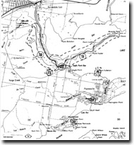
GL20 (8422) McLeod Morass
|
This information has been developed from the publications:
|
| Location: | 560103 to 506700. Four kilometres south of Bairnsdale. | |
Abstract: | Extensive blackswamp, marginal bluff, relict gravel beach and spit. | |
Access: | Track from Centre Goon Nure Road. | |
Ownership: | Private land, some Crown land. | |
Geology: | The Mitchell delta from Bairnsdale towards Eagle Point Bluff is surmounted by well defined levee banks. These slope away from the river on the western side towards the abandoned cliff that marks the former shore of Lake King during the mid-Holocene when the sea reached its present level. This cliff was outflanked by the growth of the delta and became a degraded cliff, a clear example of the marginal bluff of the Gippsland Lakes. The bluff is the edge of the low plateau that forms the hinterland to the lakes and consists of clays, sands and gravels of the Haunted Hill Gravel although, apart from the northern edge, these are covered by weathered materials and soils. | |
McLeod Morass is a freshwater swamp, now partly drained and confined as a back swamp of the Mitchell River between the sloping levee banks and the base of the marginal bluff. At the foot of the bluff and extending north from Skene Creek is a distinctive low ridge consisting of sand and pebbles. These were derived from erosion of the gravels of the former cliff (marginal bluff) and reworked to form a beach and barrier system that blocked the valley of Hollis Creek and extended, with a slight recurve, as a spit into the former embayment at the mouth of McLeod Creek. | ||
Significance: | State. The assemblage of factors described has been used as evidence that the Mitchell River silt jetties grew as a true deltaic form and are not submerged levees of a more extensive pre-Holocene flood plain system. | |
Management: | Extensive quarrying of the former beach and spit would greatly reduce the scientific interest of the site. It is important to retain the geomorphologic features of this site due to their association with the evolution of the Mitchell delta. | |
References: | Jenkin, J.J. (1968). "The geomorphology and upper Cainozoic gelogy of Southeast Gippsland, Victoria", Geol. Surv. Vict. Memoir 27. Bird (1970) Bird, E.C.F. (1978). The Geomorphology of the Gippsland Lakes Region. Publication No. 186, Environmental Studies Series, Ministry for Conservation, Victoria. | |
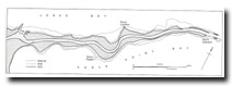
Mitchell River silt jetties and McLeod Morass (after Bird 1970
© State of Victoria (Agriculture Victoria) 1996 - .

This work, Victorian Resources Online, is licensed under a Creative Commons Attribution 4.0 licence. You are free to re-use the work under that licence, on the condition that you credit the State of Victoria (Agriculture Victoria) as author, indicate if changes were made and comply with the other licence terms.
The licence does not apply to ‘branding’ or some ‘images or photographs’ that may be owned by third parties. We ask you to seek prior approval to use images using the VRO feedback form. Access to higher quality images can also be provided on request.
This page was last updated on .