
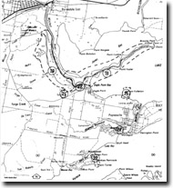
GL19 (8422) Mitchell River Delta
|
This information has been developed from the publications:
|
Location: | 600070 (8422). Bairnsdale to Point Dawson. | |
Abstract: | Eroded digitate delta. | |
Access: | Paynesville Road and Point Dawson Road from Eagle Point to southern silt jetty. The northern silt Jetty is an island. | |
Ownership: | Mostly private land. | |
Geology/Geomorphology: | The Mitchell delta extends from the vicinity of Bairnsdale southwards along the western shoreline of Lake King to Eagle Point bluff and then eastwards as long winding silt jetties bordering the Mitchell River. The silt jetties extend almost eight kilometres into the lake as low, narrow tongues of sediment that were formerly bordered by a wide zone of Phragmites reed swamp. Early descriptions of the area indicate that there was significant reed swamp on the shoreline until at least 1900 but since that time the reed swamp has largely disappeared and the river and lake shorelines of the delta are now low eroding cliffs of silty deltaic materia. | |
Comparison of 19th century maps with recent aerial photos and field surveys show that there has been considerable recession of the deltaic shorelines. As with the Tambo River delta, this is clearly related to the increased effectiveness of wave erosion following the die-back of the fringing reed swamp due mainly to the increasing salinity of Lake King since the opening of the artificial entrance. | ||
The origin of the Mitchell River silt jetties has been the subject of some debate and sever hypotheses have been advance to account for the unusually large deltaic tract of a relatively small river. It seem likely that the silt jetties are a true deltaic form consisting of silt, clay and minor sands and are comparable in configuration with those built by distributaries of the Mississippi River into the Gulf of Mexico. The major factors in their growth were the virtual absence of tidal currents in Lake King and the presence of a shoreline reed swamp fringe able to trap a large proportion of the river sediment and affording protection from wave attack. The elongated digitate form of the Mitchell silt jetties compared with the smaller cuspate deltas of the other river is a reflection of the fact that the north-western part of the other rivers is well sheltered from both westerly and easterly winds. | ||
Significance: | National and international. The Mitchell delta is a classic form of digitate delta and must rank as one of the finest examples of this type of landform in the world. | |
Management: | Apart from the small area of accretion at The Cut, erosion is predominant on all delta shorelines, and at the eastern end, the delta has been breached in several places to produce small islands. Attempts in the past to protect the shoreline with artificial structures such as wooden groynes or by introducing salt tolerant plants such as Spartina have had only limited success. A major programme of constructing and maintenance of boulder and concrete walls will be necessary to protect the soft and easily erodible muddy sediments of the delta shoreline. Continued erosion on the scale experienced over the last 70 to 80 years will essentially destroy the unified, digitate nature of the silt jetties. | |
A full appreciation of the evolution of the Mitchell delta need also to consider features discussed as Site GL-13 (Broome Point) and GL-20 (McLeod Morass - slope foot feature). | ||
References: | Clifford, H.T. (1949). "The Mitchell River Delta", Vic. Nat. 65:278. Bird, E.C.F. (1962). "The river deltas of the Gippsland Lakes", Proc. R. Soc. Vict. 57. Bird, E.C.F. (1970). "The Mitchell River Silt Jetties", Vic. Nat. 87(6):162-168. Bird, E.C.F. (1978). "The Geomorphology of the Gippsland Lakes Region", Publication No. 186, Environmental Studies Series, Ministry for Conservation, Victoria. Jenkin, J.J. (1968). "The geomorphology and Upper Cainozoic geology of Southeast Gippsland, Victoria", Geol. Surv. Vict. Memoir 27. Bird, E.C.F. & Rosengren, N.J. (1971). The disappearing Mitchell delta", Proc. R. Soc. Vict., 84:153-8. | |
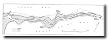
The past and present configuration of the
Mitchell River silt jetties
© State of Victoria (Agriculture Victoria) 1996 - .

This work, Victorian Resources Online, is licensed under a Creative Commons Attribution 4.0 licence. You are free to re-use the work under that licence, on the condition that you credit the State of Victoria (Agriculture Victoria) as author, indicate if changes were made and comply with the other licence terms.
The licence does not apply to ‘branding’ or some ‘images or photographs’ that may be owned by third parties. We ask you to seek prior approval to use images using the VRO feedback form. Access to higher quality images can also be provided on request.
This page was last updated on .