
GL16 (8422) Shaving Point and floor of Lake King
|
This information has been developed from the publications:
|
| Location: | 753050 (8422). Metung. | |
Abstract: | Narrow promontory and deep hole on floor of Lake King. | |
Access: | Metung Road. | |
Ownership: | Mainly private land onshore, Crown land on Lake King. | |
Geomorphology: | Tertiary sediments (Jemmys Point Formation), overlain by Haunted Hill Gravels and Pleistocene sand and gravel. | |
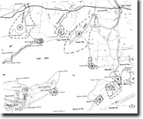
Shaving Point is a narrow peninsula projecting southwards from the marginal bluff at Metung into Lake King and hence constricting the connection between this lake and Bancroft Bay to the east. The point has the configuration of an arrow spit, built at a point of convergence of two directions of longshore drifting of beach gravel. It is surrounded by eroding sand and gravel beaches and has been extensively modified by shoreline engineering works and jetty construction. Beach nourishment programmers have been carried out on the western shoreline. | ||
South-east of the point, the floor of Lake King deepens rapidly to over 15 metres and comparisons of the bathymetry with that shown on maps produced in the late 19th century suggest that depths have increased here by 3 to 5 metres. This deepening has been ascribed to tidal scour produced by flood-tide currents entering Lake King from Lakes Entrance via Reeve Channel. If this assessment is correct, the erosion or deepening of the scour hole or “tidal colk” provides a further incidence of physiographic change introduced by the maintenance of a permanent opening into the Gippsland Lakes. | ||
Significance: | Regional. The origin of Shaving Point may not be as simple as outlined above as the sandy/gravely material may lie on a drowned, truncated spur of Tertiary sediments. | |
Management: | Continued beach nourishment schemes are necessary if extensive erosion of the western shoreline is to be arrested. | |
References: | Bird (1976) Bird, E.C.F. (1978). The Geomorphology of the Gippsland Lakes Region. Publication No. 186, Environmental Studies Series, Ministry for Conservation, Victoria. King (1980a, 1980b). | |
© State of Victoria (Agriculture Victoria) 1996 - .

This work, Victorian Resources Online, is licensed under a Creative Commons Attribution 4.0 licence. You are free to re-use the work under that licence, on the condition that you credit the State of Victoria (Agriculture Victoria) as author, indicate if changes were made and comply with the other licence terms.
The licence does not apply to ‘branding’ or some ‘images or photographs’ that may be owned by third parties. We ask you to seek prior approval to use images using the VRO feedback form. Access to higher quality images can also be provided on request.
This page was last updated on .