
GL12 (8422) Nicholson River Delta
|
This information has been developed from the publications:
|
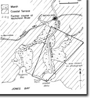
| Location: | 645112 (8422). Northern shore of Jones Bay in Lake King. | 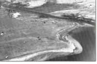 Eroded delta of the Nicholson River |
Abstract: | Eroded river delta, old river course. | |
Access: | Boat from Lake King. | |
Ownership: | Private land. | |
Geomorphology: | The Nicholson River initially flowed into Lake King through Nugents Bay but the lower course has been captured by a smaller stream and the river now enters to the east of Nugents Bay. The small delta that protruded here has been consumed by erosion. | |
Significance: | Regional. This is an unusual example of river capture. | |
Management: | Erosion is continuing on the delta remnant and would accelerate with increased boating activity in the river. Boat speed limits should be enforced. | |
References: | Bird, E.C.F. (1978). The Geomorphology of the Gippsland Lakes Region. Publication No. 186, Environmental Studies Series, Ministry for Conservation, Victoria. | |
© State of Victoria (Agriculture Victoria) 1996 - .

This work, Victorian Resources Online, is licensed under a Creative Commons Attribution 4.0 licence. You are free to re-use the work under that licence, on the condition that you credit the State of Victoria (Agriculture Victoria) as author, indicate if changes were made and comply with the other licence terms.
The licence does not apply to ‘branding’ or some ‘images or photographs’ that may be owned by third parties. We ask you to seek prior approval to use images using the VRO feedback form. Access to higher quality images can also be provided on request.
This page was last updated on .