
GL10 (8422) Tambo River Delta
|
This information has been developed from the publications:
|
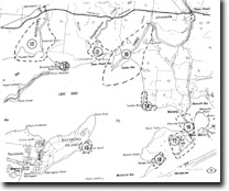
| Location: | 705100 (8422). 4 kilometres south-west of Johnsonville (northern bank) or 9 kilometres south-west of Swan Reach (southern bank). | |
Abstract: | Eroding cuspate river delta. | |
Access: | Dry weather track from Johnsonville through private property or public road from Swan Reach. Boat landing may be made readily on the river shores. | |
Ownership: | Mostly private land. | |
Geology: | The delta consists of silts, clays and sands, and swamp deposits which overly sands and gravels deposited in an earlier river channel incised during Pleistocene low sea levels to 10 to 15 metres below present sea level. The deltaic deposits extend upstream approximately to Swan Reach and pass laterally into fluvial sediments of the narrow Tambo River flood plain. The valley side bluffs are cut into sediments of the Tambo River Formation and Jemmys Point Formation overlain by Haunted Hill Gravels. | |
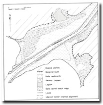
Geomorphology: | The delta is of elongated cuspate shape protruding 2.5 kilometres south-westward into Lake King, the southern arm extending 160 metres beyond the northern. The delta has first infilled a funnel-shaped embayment and continued sedimentation has extended the delta into Lake King. Sands and minor gravels have been initially deposited by wave and current action as beaches fringing the valley side bluffs. These shoreline deposits were provided partly by erosion of the lake shore cliffs and partly from the floor of Lake King. They accumulated when the embayment and valley of the Tambo River was first flooded by the rising waters from Holocene marine transgression, culminating approximately 6,000 years ago. Fluvial and deltaic sedimentation was facilitated by the growth of reed swamp which caused wave energy to diminish and reduced the effectiveness of wave induced currents in dispersing the sediments load from the river. | |
The delta is an area of low relief and the northern arm includes and extensive zone of lagoon and swamp. The river channel is bordered by low natural levee banks up to two metres in height, decreasing towards the mouth to below one metre. The wetland areas are back swamps or elongated flood basins where drainage is impounded between the levee and the valley side bluff. There are no cut-off bends or abandoned distributaries on the delta but there are several isolated segments of levee bank which lie parallel to the channel and enclose a long, narrow swamp lagoon. These occur on alternate sides of the river and indicate a former channel more sinuous in pattern than the modern channel suggesting a recent change in the hydraulic regime, e.g. an increase in discharge, an increase in velocity of the river, or a change in the sediment load. | ||
Comparison of maps made during the 19th century and aerial photographs taken between 1940 and 1976 indicate that considerable erosion of the delta is taking place. The southern arm has receded by approximately 500 metres since 1849 and detailed field mapping since 1970 has shown that some sectors are retreating at rates of up to 10 metres per year. | ||
The critical factor in shoreline erosion here, as with the Mitchell River delta, appears to be the die-back of fringing reed swamp as a result of salinity increase in the lakes since 1889. Other factors such as trampling by cattle grazing on the river banks, access by fishermen, and scouring by boat wash are of increasing importance as the reed fringe disappears. | ||
Significance: | State. This is a major example of the processes of delta growth and little detailed investigation has been undertaken here. | |
Management: | Erosion will continue unless suitable plants or artificial structures are emplaced along the shoreline. Most erosion of the lake shorelines is by wave action while the river bank is affected particularly by swash set up by power boating. An increase in boating activity in the river will increase the erosion problem. | |
References: | Bird, E.C.F. (1978). The Geomorphology of the Gippsland Lakes Region. Publication No. 186, Environmental Studies Series, Ministry for Conservation, Victoria. | |
 Morphology of the Tambo Delta | 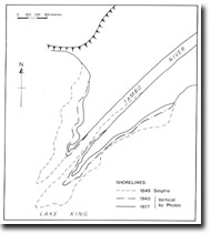 Shoreline changes, Tambo Delta |
© State of Victoria (Agriculture Victoria) 1996 - .

This work, Victorian Resources Online, is licensed under a Creative Commons Attribution 4.0 licence. You are free to re-use the work under that licence, on the condition that you credit the State of Victoria (Agriculture Victoria) as author, indicate if changes were made and comply with the other licence terms.
The licence does not apply to ‘branding’ or some ‘images or photographs’ that may be owned by third parties. We ask you to seek prior approval to use images using the VRO feedback form. Access to higher quality images can also be provided on request.
This page was last updated on .