
GL 3 Cunninghame Arm
|
This information has been developed from the publications:
|
Location: | 920083 to 880070 (8522). South-east of Lakes Entrance. | 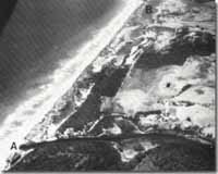 Site of natural entrance to the Gippsland Lakes at Lake Bunga (A), prior to the opening of the artificial entrance. Cunninghame Arm (B), now resricted by segmentation. |
Abstract: | Segmented coastal lagoon; former natural entrance to Gippsland Lakes. | |
Access: | Footbridge at Lakes Entrance; Lake Bunga Road. | |
Ownership: | Crown land. | |
Geology: | Before the opening of the artificial channel across the outer barrier at Lakes Entrance, the inlet to the Gippsland Lakes had occupied various positions, sometimes being as far east as within 200 metres of Red Bluff. Since the opening of the artificial entrance in 1889, the former natural outlet has sealed off and the long, narrow channel that connected the lake to this opening (Reeve River) has been largely infilled by sedimentation. Apart from Lake Bunga, very little evidence remains of the position of the former entrances. Cunninghame Arm clearly illustrates the process of lake segmentation i.e. the conversion of a long, narrow lagoon into a series of smaller, rounded to oval shaped lakes divided by elongated cuspate spits. These spits are prominent on the southern shore of Cunninghame Arm east of the Lakes Entrance footbridge. | |
Significance: | National. This site demonstrates clearly some physiographic consequences of the opening of the artificial entrance at Lakes Entrance. It provides a classic example of active lake shore segmentation. | |
Management: | Dumping of dredging spoil, land reclamation projects, or extension of shoreline protection works will interfere with the rates and processes of sedimentation and should be prohibited in Cunninghame Arm. | |
References: | Bird, E.C.F. (1978). The Geomorphology of the Gippsland Lakes Region. Publication No. 186, Environmental Studies Series, Ministry for Conservation, Victoria. | |
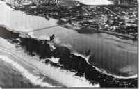 Shoreline cusps (arrowed) - Cunninghame Arm | 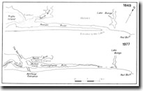 Shoreline changes in the Cunninghame Arm, (from Bird, 1978) |
© State of Victoria (Agriculture Victoria) 1996 - .

This work, Victorian Resources Online, is licensed under a Creative Commons Attribution 4.0 licence. You are free to re-use the work under that licence, on the condition that you credit the State of Victoria (Agriculture Victoria) as author, indicate if changes were made and comply with the other licence terms.
The licence does not apply to ‘branding’ or some ‘images or photographs’ that may be owned by third parties. We ask you to seek prior approval to use images using the VRO feedback form. Access to higher quality images can also be provided on request.
This page was last updated on .