
8823-4 Lower Wallagaraugh/Genoa District
|
This information has been developed from the publications:
|
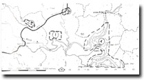
Location: | 370495. Area around Gypsy Point. | |
Abstract: | Deltas at river confluence, drowned valley | |
Access: | Gypsy Point Road | |
Ownership: | Crown Land (including National Park) with small enclaves of privately owned land. | |
Geology: | The Genoa and Wallagaraugh Rivers have cut valleys through Ordovician sandstones, slates and shales. These sediments are exposed on the channel edges and in the shoreline of the estuarine river channel of Mallacoota Inlet. Both rivers in small floodplains and terraces deposit alluvium while at the confluence of the rivers digitate deltas have formed. | |
Significance: | During Pleistocene lower sea levels the Genoa and Wallagaraugh Rivers incised valleys into Ordovician sediments. These valleys have been flooded by the rise in the sea level associated with the Holocene marine transgression. The river channels upstream from the confluence are generally shallow and encumbered by extensive sand bar development. Downstream from the confluence the drowned valley is deep and generally “V” shaped, with several large relict river scour holes, one near Cape Horn reaching 25 metres in depth. The hydrological regime of this site is of particular interest. Salinity, temperature, pH, and nutrient levels vary considerably and this variation is dependent on river discharge. High river discharge produces dramatic reductions in surface salinity, temperature and pH while nutrient levels generally increase. During periods of low river discharge, the lower river channels are essentially marine dominated and tend to have salinities, temperatures, pH and nutrient levels similar to those of the Upper Lake of Mallacoota Inlet. | |
Management: | State. Best example in Victoria of a drowned river valley estuary. The digitate delta forms of alluvial deposition are uncommon and well displayed at this site. | |
References: | Accelerated sedimentation of the lower river channels and estuarine river channel may occur if substantial land disturbance occurs in the catchment of the rivers. Preliminary hydrological studies have indicated the possibility of pollution through septic tank seepage in the Gypsy Point area. It is recommended that if any further development is proposed for this area that it be located as far as is possible from the river channels and the upper estuarine section of Mallacoota Inlet. | |
© State of Victoria (Agriculture Victoria) 1996 - .

This work, Victorian Resources Online, is licensed under a Creative Commons Attribution 4.0 licence. You are free to re-use the work under that licence, on the condition that you credit the State of Victoria (Agriculture Victoria) as author, indicate if changes were made and comply with the other licence terms.
The licence does not apply to ‘branding’ or some ‘images or photographs’ that may be owned by third parties. We ask you to seek prior approval to use images using the VRO feedback form. Access to higher quality images can also be provided on request.
This page was last updated on .