
8822-9 Tullaberga Island
This information has been developed from the publications:
|
Location: | 513393. Tullaberga Island is 7 km east of the entrance to Mallacoota Inlet and 1 km from the coastline. | 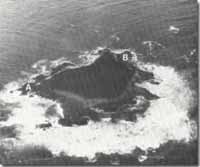 Tullaberga Island - Ordovician metasediments (A), Gabo Island Granite (B). |
Abstract: | Low island of granite and Ordovician sediments displaying narrow contact metamorphic zone. | |
Access: | Difficult boat landing may be made at several points depending on the state of the sea. | |
Ownership: | Crown Land (Crojingolong National Park). | |
Geology: | Tullaberga Island consists of an outlier of red Gabo Island Granite which has intruded the grey sandstone and shale of the Ordovician Mallacoota Beds. Outcrops are accessible only on the shore platform around the island. The sediments strike to the north-east and dip 50o – 70o to the south-east. These beds are faulted on the south-west of the island. Along the granite contact is a narrow zone of metamorphism – in most areas only 2-3 m wide, apart from a belt of hornfels up to 40 m wide on the south-eastern shoreline. Basatic dykes are prominent in the granites on the eastern side – the largest dyke being almost 2 m wide. Minor and less conspicuous aplite dykes occur just north of the basic dyke zone. Elsewhere on the island the bedrock is covered thinly by beach and dune sands and vegetated with a dune coastal scrub. | |
Geomorphology: | The island is low and rises only 10-15 m above sea level. It is surrounded by a rocky patform, and has only small areas of sand and gravel beach. There are six small granite islands on the eastern side and several larger reefs of sedimentary rock on the west. In contrast with Gabo Island there is no obvious dune topography on Tullaberga Island. | |
Significance: | Local. The contact between the granite and Ordovician sedimentary rocks is clearly seen and the number of basic dykes extending through the granite is of geological interest. | |
Management: | This should aim to preserve the contact zones and the main basaltic dykes. | |
References: | Douglas, J.G. 1978. 'Geology of Tullaberga Island and the adjacent mainland', Min. geol. J. Vict., 7(3) :31-33. | |
 Sites 8822-1 to 10 |

© State of Victoria (Agriculture Victoria) 1996 - .

This work, Victorian Resources Online, is licensed under a Creative Commons Attribution 4.0 licence. You are free to re-use the work under that licence, on the condition that you credit the State of Victoria (Agriculture Victoria) as author, indicate if changes were made and comply with the other licence terms.
The licence does not apply to ‘branding’ or some ‘images or photographs’ that may be owned by third parties. We ask you to seek prior approval to use images using the VRO feedback form. Access to higher quality images can also be provided on request.
This page was last updated on .