
8822-3 Telegraph Point
This information has been developed from the publications:
|
Location: | 565410. 12 km east of entrance to Mallacoota Inlet. | 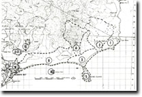 Sites 8822-1 to 10 |
Abstract: | Cuspate foreland with active transverse dune ridges. | |
Access: | Walking access only from Mallacoota Inlet or termination of 4-whee drive track across Howe Flat. | |
Ownership: | Crown Land (Croajingolong National Park). | |
Geology: | Quaternary dune sands and minor swamp deposits. | |
Geomorphology: | Telegraph Point is a large cuspate foreland developed by wave refraction around Gabo Island and comprises a complex of active and stabilized parabolic dunes, mobile transverse dune ridges and small barchan dunes. Numerous inter-dune lakes and swamps occur and temporary lagoons are impounded on the eastern side of the point by the formation of small spits and bars. The open and western side of the foreland consist of a wide beach from which sand is blown into hummocky dunes, transverse ridges and barchans which migrate downwind and spill into the sea along the eastern side. During part of the 19th century the foreland was linked to Gabo Island as a tombolo but this connection has not been maintained since 1889. The accidental introduction and spread of Ammophila arenaris along the shoreline is leading to rapid physiographic changes in the coastal dunes. | |
Significance: | National. This is one of the largest sandy forelands in south-eastern Australia and displays a variety of aeolian accumulation forms. It is a major site for the study of dune dynamics, for changes that have taken place over historical time and for the monitoring of the affect of introduced plant species on the configuration of coastal dunes. | |
Management: | Motor vehicles of all types should be excluded from the dune areas between Mallacoota Inlet and Cape Howe. | |
References: | Rosengren, N. J. 1978. The Physiography of Coastal Dunes, East Gippsland, Victoria. M. A. Thesis (Unpub.), University of Melbourne. Rosengren, N.J. 1980, 'Dune Systems on Cuspate forelands, East Gippsland, Victoria', Proc. R. Soc. Vict., 92 :106-119. | |
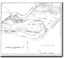
Telegraph Point (from Rosengren, 1978)
© State of Victoria (Agriculture Victoria) 1996 - .

This work, Victorian Resources Online, is licensed under a Creative Commons Attribution 4.0 licence. You are free to re-use the work under that licence, on the condition that you credit the State of Victoria (Agriculture Victoria) as author, indicate if changes were made and comply with the other licence terms.
The licence does not apply to ‘branding’ or some ‘images or photographs’ that may be owned by third parties. We ask you to seek prior approval to use images using the VRO feedback form. Access to higher quality images can also be provided on request.
This page was last updated on .