
8822-2 Lake Wau Wauka
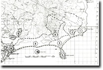
Sites 8822 1 to 10 - Mallacoota to Cape Howe
Page top
This information has been developed from the publications:
|
Location: | 587445. The main body is 5 km west of Cape Howe and 1 km inland. | 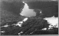 Abandoned shoreline ridge (A) - Lake Wau Wauka. |
Abstract: | Fresh water dune-blocked lake with fringing sedge and reed swamp. | |
Access: | Walking access only from the coast via Mallacoota or the Nadgee Nature Reserve (NSW). | |
Ownership: | Crown Land (Croajingolong National Park) and Crown Land (NSW). | |
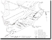
Geology: | The lake basin is contained in Quaternary dune sands, muds and organic matter forming the lake floor. | |
Geomorphology: | Wau Wauku is a “leg of mutton” shaped freshwater lake which results from the impounding of a small stream system by transgressive coastal dunes. The lake is connected tot he sea by an intermittent outflow channel. The present open water section comprises only 1/3 of the total lake basin, the upper sections are now occupied by freshwater reed and sedge swamp. Several relict shoreline features indicate that higher lake levels and a more extensive open water surface existed during the late Pleistocene and Holocene. These features include spits, abandoned cliffs and a lunette ridge on the eastern side of the lake where wave action due to westerly winds would have been more effective. Details of the lake bathymmetry, biology and water chemistry are unknown. | |
Significance: | State. The site is a rare example of a stream blocked by coastal dunes to form a lake with subsequent shallowing and swamp reclamation. Geomorphological and palynological studies are needed to determine the chronology of lake and swamp formation and to relate this to late Quaternary climatic and sea level changes. This site offers and important opportunity for these studies because of the lack of disturbance in the catchment and drainage system of the lake. | |
Management: | Protection of the catchment system from soil erosion and changes in water quality are necessary to preserve the significance of the site. | |
References: | Rosengren, N. J. 1978. The Physiography of Coastal Dunes, East Gippsland, Victoria. M. A. Thesis (Unpub.), University of Melbourne | |
 Sites 8822-1 to 10 |
© State of Victoria (Agriculture Victoria) 1996 - .

This work, Victorian Resources Online, is licensed under a Creative Commons Attribution 4.0 licence. You are free to re-use the work under that licence, on the condition that you credit the State of Victoria (Agriculture Victoria) as author, indicate if changes were made and comply with the other licence terms.
The licence does not apply to ‘branding’ or some ‘images or photographs’ that may be owned by third parties. We ask you to seek prior approval to use images using the VRO feedback form. Access to higher quality images can also be provided on request.
This page was last updated on .