
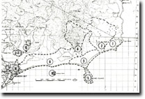
8822-1 to 10 Mallacoota to Cape Howe
|
This information has been developed from the publications:
|
Location: | The sites inidcated display aspects of the geology and geomorphology of Mallacoota Inlet, the Howe Range, and the coastal dunes and wetlands east of Telegraph Point. Several features are of outstanding significance for the study of estuary and dune dynamics and there are major reference sites for two geological formations (Gabo Island Granite, Merimbula Group) not represented elsewhere in Victoria. | |
Mallacoota Inlet is a large, branching compound estuary formed by the submergence of the lower valleys of the Genoa and Wallagaraugh rivers adn the partial enclosure of a marine embayment by sand barrier and dune accumulation. At least one pre-Holocene phase of submergence is represented by remnants of a barrier formation that occurs as the Goodwin Sands and along the northern edge of Howe Inlet. This earlier barrier has been dissected during lower sea level phaes and displays a leached soil profile overlying hard brown "coffee-rock" indicating a lengthy period of weathering and soil development. | ||
Since the mid-Holocene sumbergence of Mallacoota Inlet (approximately 6,000 year ago), sedimentation due to rive inflow, tidal currents wind action and accumulation of salt marsh and freshwater swamps has substantial reduced the area of open water and has isolated several lakes and lagoons around the estuary margin (e.g. Lake Barracoota). | ||
The sites selected in and adjacent to Mallacoota Inlet display stages in the formation of the estuary and provide examples of the main sedimentary processes that modify its configuration. | ||
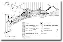
The ocean east of Mallacoota entrance is predominantly sandy but a short rocky sector occurs from Iron Prince Reef to Cape Howe. Of major significance are the cuspate forelands developed in the lee of Tullaberga and Gabo Islands as these largely determine the pattern of dune sedimentation on this sector of coast. | ||
References: | Rosengren, N. J. 1978. The Physiography of Coastal Dunes, East Gippsland, Victoria. M. A. Thesis (Unpub.), University of Melbourne | |
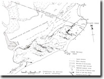 Lake Wau Wauka to Cape Howe. Contours on mobile sand surface - 1973, (from Rosengren, 1978) |
© State of Victoria (Agriculture Victoria) 1996 - .

This work, Victorian Resources Online, is licensed under a Creative Commons Attribution 4.0 licence. You are free to re-use the work under that licence, on the condition that you credit the State of Victoria (Agriculture Victoria) as author, indicate if changes were made and comply with the other licence terms.
The licence does not apply to ‘branding’ or some ‘images or photographs’ that may be owned by third parties. We ask you to seek prior approval to use images using the VRO feedback form. Access to higher quality images can also be provided on request.
This page was last updated on .