
8822-14 Red River lagoon
|
This information has been developed from the publications:
|
Location: | 262223. 6.5 kilometres east of Wingan Inlet | 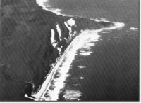 Red River estuary (foreground), and parabolic dunes - Sandpatch Point. |
Abstract: | Estuarine lagoon and river delta. | |
Access: | Coastal walk from Wingan Inlet or Bennedore River. Sandpatch track or Red River from East Wingan Road. | |
Ownership: | Crown Land (Croajingolong National Park). | |
Geology: | The catchment of Red River is developed on Maramingo Granite with a discontinuous capping of Tertiary sediments. The granite outcrops in the river channel and forms a small set of rapids at the head of Red River lagoon. | |
Geomorphology: | The estuarine section of Red River extends for approximately 1.5 kilometres and consists of a deep drowned river channel cut in granite which opens through a lobate reed and sedge fringed delta into a shallow sandy lagoon. The lagoon entrance is in the lee of small granite rocks and reefs two kilometres west of Sandpatch Point. The entrance is often closed by a sand bar. | |
Significance: | Regional. The river catchment and lagoon have been little modified by man and preserve the physical and hydrological characteristics of a small estuarine system. | |
Management: | To be of value as a reference site, disturbance to the vegetation, soils and runoff in the catchment should be avoided. Logging, or clearing or road and bridgework on the catchment should be prohibited as also should be power boating on the river and lagoon. Camping sites should be located well away from the river sides. Restrictions on forestry and vehicle traffic and location of camping areas from the lagoon shores are necessary to maintain the scientific value of the estuary and lagoon. | |
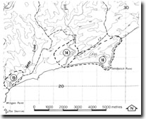
Sites 8822 14, 15, 16
© State of Victoria (Agriculture Victoria) 1996 - .

This work, Victorian Resources Online, is licensed under a Creative Commons Attribution 4.0 licence. You are free to re-use the work under that licence, on the condition that you credit the State of Victoria (Agriculture Victoria) as author, indicate if changes were made and comply with the other licence terms.
The licence does not apply to ‘branding’ or some ‘images or photographs’ that may be owned by third parties. We ask you to seek prior approval to use images using the VRO feedback form. Access to higher quality images can also be provided on request.
This page was last updated on .