
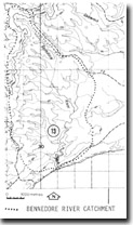
8822-13 Bennedore River Catchment
|
This information has been developed from the publications:
|
Location: | 310244. The area designated is the entire catchment of the Bennedore River and, in particular, the estuarine lagoon 20 kilometres south-west of Mallacoota. | 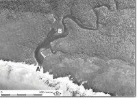 Bennedore River estuary - blind entrance (A), river delta (B). |
Abstract: | Relatively undisturbed catchment of small coastal stream with estuarine lagoon. | |
Access: | 4 Wheel drive track from Mallacoota Airport. | |
Ownership: | Crown Land (Croajingolong National Park) | |
Geology: | The headwaters and steepest sections of the catchment are on granite rocks (Maramingo Granite) while the lower reaches of the Bennedore are incised into the Ordovician sediments (Mallacoota Beds) with a thin cover of Tertiary sands. The Mallacoota Beds outcrop along the steep valley sides of the Bennedore estuarine lagoon. | |
Geomorphology: | Stream valleys are well defined on the granitic rocks in the north and west of the catchment but the smaller tributaries from the east include swampy sections across the Tertiary sediments. The lower valley is deeply incised into the Ordovician sediments and has the form of a small ria or drowned river valley that opens through a delta into a narrow estuarine lagoon. The outlet of the lagoon to the sea is frequently blocked by a sand barrier but when this entrance is open, tidal flow extends up to 1.5 kilometres into the river. The salinity regime of this section is therefore highly variable. | |
Significance: | Regional. The Bennedore represents one of the least modified stream catchments on the East Gippsland coast as there has been minimal forestry or land clearing activities over its area. The river and estuarine lagoon may be used as an important reference site to study the hydrology and hydrochemistry of such systems which are relatively free from human interference. | |
Management: | To be of value as a reference site, disturbance to the vegetation, soils and runoff in the catchment should be avoided. Logging, or clearing or road and bridgework on the catchment should be prohibited as also should be power boating on the river and lagoon. Camping sites should be located well away from the river sides. | |
Sites 8822 13
© State of Victoria (Agriculture Victoria) 1996 - .

This work, Victorian Resources Online, is licensed under a Creative Commons Attribution 4.0 licence. You are free to re-use the work under that licence, on the condition that you credit the State of Victoria (Agriculture Victoria) as author, indicate if changes were made and comply with the other licence terms.
The licence does not apply to ‘branding’ or some ‘images or photographs’ that may be owned by third parties. We ask you to seek prior approval to use images using the VRO feedback form. Access to higher quality images can also be provided on request.
This page was last updated on .