
8822-1 Iron Prince Reef - Cape Howe
Sites 8822 1 to 10 - Mallacoota to Cape Howe
Page top
This information has been developed from the publications:
|
Location: | Mallacoota 615445. Coastal area extending 2 km south-west from Cape Howe and 1 km inland. | 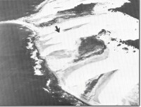 Transverse dunes - Cape Howe to Iron Prince Reef. Arrow indicates dominant wind direction. |
Abstract: | Active transverse dune ridges behind rocky foreshore. | |
Access: | From Victoria the most direct access is by foot around the beach from Mallacoota or from termination of 4-wheel drive tracks on Howe Flat. Restricted walking access is possible from New South Wales via the Nadgee Nature Reserve. | |
Ownership: | Crown Land (Croajingolong National Park). | |
Geology: | Red and brown sandstone and shale beds of the Merimbula Formation outcrop at Iron Prince Reef an north-eastward along the coast to Cape Howe. Limited exposures occur between dune ridges inland. At the reef, the beds strike north-westerly with dips 300 to 400 to the north-east. Dips decrease to 80 to 100 near Cape Howe. | |
Geomorphology: | The outline of Iron Prince Reef is determined by the strike of the sediments and the outcrops on deflation surfaces inland from low but prominent strike ridges. Smaller reefs and an irregular shore platform occur towards Cape Howe and are in part covered with an irregular boulder and cobble beach. Of major geomorphological significance are parallel sets of active sand ridges that lie transverse to the prevailing south-westerly winds and are advancing down-wind between Lake Wau-Wauka and Cape Howe. At Cape Howe where the coast trends northerly, the ridges are blown from the land back into the sea. | |
Significance: | State. The outcrops of sedimentary rock are the only exposures of the Merimbula Group on the Victorian coast. The sand dunes constitute a major example of an active transverse ridge sequence undergoing rapid change. | |
Management: | Policies should be directed at preservation of the rock outcrops and minimizing the disturbance to the mobile dune ridges, e.g. by vehicle traffic. Stabilization or re-vegetation of the active dunes would reduce their scientific interest. | |
References: | Rosengren, N.J. 1978. The Physiography of Caostal Dunes, East Gippsland, Victoria. M.A. Thesis (unpub.), University of Melbourne. Rosengren, N.J. 1980, 'Dune Systems on Cuspate forelands, East Gippsland, Victoria', Proc. R. Soc. Vict., 92 :106-119. | |
 Sites 8822-1 to 10 |
© State of Victoria (Agriculture Victoria) 1996 - .

This work, Victorian Resources Online, is licensed under a Creative Commons Attribution 4.0 licence. You are free to re-use the work under that licence, on the condition that you credit the State of Victoria (Agriculture Victoria) as author, indicate if changes were made and comply with the other licence terms.
The licence does not apply to ‘branding’ or some ‘images or photographs’ that may be owned by third parties. We ask you to seek prior approval to use images using the VRO feedback form. Access to higher quality images can also be provided on request.
This page was last updated on .