
8723-9 Mount Coopracambra
|
This information has been developed from the publications:
|
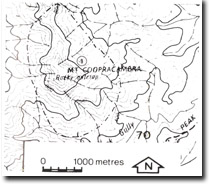
Location: | 035715. 13 kilometres north-east of Weeragua | |
Abstract: | Prominent peak with outcrops of Noorinbee Granodiorite and substantial landslide. | |
Access: | Three kilometres walk from Yambulla peak track. | |
Ownership: | Crown Land (Coopracambra State Park). | |
Geology/Geomorphology: | Mount Coorpracambra rises to more than 900 metres and as such is the most prominent landscape feature of this area. Noorinbee Granodiorite is exposed on the western slopes of the mount and minor tor development occurs on the peak itself. A large landslide is a prominent feature of the northern slopes (038725). | |
Significance: | Local. The granitic peak of Mount Coopracambra provides a scenically spectacular backpack to the surrounding river gorge topography of the Genoa River. | |
Management: | Slope instability will need to be considered in any proposed walking track or road construction in the area. | |
© State of Victoria (Agriculture Victoria) 1996 - .

This work, Victorian Resources Online, is licensed under a Creative Commons Attribution 4.0 licence. You are free to re-use the work under that licence, on the condition that you credit the State of Victoria (Agriculture Victoria) as author, indicate if changes were made and comply with the other licence terms.
The licence does not apply to ‘branding’ or some ‘images or photographs’ that may be owned by third parties. We ask you to seek prior approval to use images using the VRO feedback form. Access to higher quality images can also be provided on request.
This page was last updated on .